Mariscala geodata
Mariscala (Puebla) is a populated place; located in Mexico in America/Mexico_City (GMT-6) time zone. With population of 510 people, there are 16480 cities with bigger population in this country. Compared to other cities in Mexico, 72.4% of cities are located further ↑North; 64.6% of cities are located further ←West and 64.7% of cities have lower elevation than Mariscala. Note1


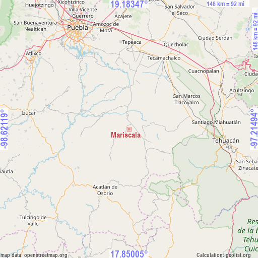
Mariscala GPS coordinates[2]
18° 31' 5.016" North, 97° 55' 5.016" West
| Map corner | latitude | longitude |
|---|---|---|
| Upper-left | 19.18347°, | -98.62119° |
| Center: | 18.51806°, | -97.91806° |
| Lower-right: | 17.85005°, | -97.21494° |
| Map W x H: | 148.3×148.3 km | = 92.1×92.1mi |
| max Lat: | 32.7° ⇑72.4% North |
| Mariscala: | 18.51806° |
| min Lat: | ⇓27.6% South 14.53588° |
| min Long | Mariscala | max Long |
| -117.105° | -97.91806° | -86.73105° |
| W 64.6%⇐ | ⇒35.4% E |
Elevation
Elevation of Mariscala is 1820 m = 5971 ft, and this is 566.3 m = 1858 ft above average elevation for this country.
| Max E: |
3497 m = 11473 ft | 35.3% |
| Mariscala | 1820 m 5971 ft | |
| Avg. | 1253.7 m = 4113 ft | |
Min E: |
-1 m = -3 ft | 64.7% |
See also: Mexico elevation on elevation.city.
Geographical zone
Mariscala is located in North Torrid zone (between Equator and Tropic of Cancer). Distance of this Northern Tropic circle is 546.9 km =339.8 mi to North.| Distance of | km | miles | from Mariscala |
|---|---|---|---|
| North Pole | 7948 | 4938.7 | to North |
| Arctic Circle | 5342.2 | 3319.5 | to North |
| Tropic Cancer | 546.9 | 339.8 | to North |
| Equator | 2059 | 1279.4 | to South |


Nearby cities:
15 places around Mariscala: (largest is in red/bold)
• Agua Santa Ana
4 km =2.5 mi,  266°
266°
• Almolonga
6.7 km =4.2 mi,  225°
225°
• Chapultepec (Santo Domingo)
8.4 km =5.2 mi,  245°
245°
• Colonia Morelos (Pie de Vaca)
8.6 km =5.3 mi,  1°
1°
• El Progreso
7.9 km =4.9 mi,  53°
53°
• El Rosario Xochitiopan
13.9 km =8.6 mi,  342°
342°
• Guadalupe Victoria
8 km =5 mi,  74°
74°
• Huajoyuca
2.1 km =1.3 mi, 252°
• Huejonapan
5.4 km =3.4 mi,  183°
183°
• Moralillo
4.3 km =2.7 mi,  320°
320°
• San Felipe Otlaltepec
13 km =8.1 mi, 175°
• San Juan Ixcaquixtla
11.2 km =7 mi,  124°
124°
• Tepexi de Rodríguez
7.1 km =4.4 mi,  353°
353°
• Tula
2.5 km =1.6 mi,  21°
21°
• Victoria
15.4 km =9.6 mi, 350°
Sources, notices
• [Note1] Compared only with cities in Mexico existing in our database
• [Src1] Map data: © OpenStreetMap contributors (CC-BY-SA)
• [Src2] Other city data from geonames.org with taken over terms of usage.
• [Src3] Geographical zone / Annual Mean Temperature by Robert A. Rohde @ Wikipedia
