Huejonapan geodata
Huejonapan (Puebla) is a populated place; located in Mexico in America/Mexico_City (GMT-6) time zone. With population of 1,753 people, there are 4956 cities with bigger population in this country. Compared to other cities in Mexico, 72.9% of cities are located further ↑North; 64.6% of cities are located further ←West and 63.8% of cities have lower elevation than Huejonapan. Note1


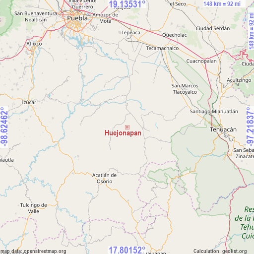
Huejonapan GPS coordinates[2]
18° 28' 10.956" North, 97° 55' 17.364" West
| Map corner | latitude | longitude |
|---|---|---|
| Upper-left | 19.13531°, | -98.62462° |
| Center: | 18.46971°, | -97.92149° |
| Lower-right: | 17.80152°, | -97.21837° |
| Map W x H: | 148.3×148.3 km | = 92.1×92.1mi |
| max Lat: | 32.7° ⇑72.9% North |
| Huejonapan: | 18.46971° |
| min Lat: | ⇓27.1% South 14.53588° |
| min Long | Huejonapan | max Long |
| -117.105° | -97.92149° | -86.73105° |
| W 64.6%⇐ | ⇒35.4% E |
Elevation
Elevation of Huejonapan is 1797 m = 5896 ft, and this is 543.3 m = 1782 ft above average elevation for this country.
| Max E: |
3497 m = 11473 ft | 36.2% |
| Huejonapan | 1797 m 5896 ft | |
| Avg. | 1253.7 m = 4113 ft | |
Min E: |
-1 m = -3 ft | 63.8% |
See also: Mexico elevation on elevation.city.
Geographical zone
Huejonapan is located in North Torrid zone (between Equator and Tropic of Cancer). Distance of this Northern Tropic circle is 552.3 km =343.2 mi to North.| Distance of | km | miles | from Huejonapan |
|---|---|---|---|
| North Pole | 7953.4 | 4942 | to North |
| Arctic Circle | 5347.5 | 3322.8 | to North |
| Tropic Cancer | 552.3 | 343.2 | to North |
| Equator | 2053.6 | 1276 | to South |


Nearby cities:
15 places around Huejonapan: (largest is in red/bold)
• Agua Santa Ana
6.3 km =3.9 mi,  325°
325°
• Ahuatempan
12 km =7.5 mi,  238°
238°
• Almolonga
4.5 km =2.8 mi,  279°
279°
• Chapultepec (Santo Domingo)
7.5 km =4.7 mi, 284°
• El Progreso
12.1 km =7.5 mi,  33°
33°
• Guadalupe Victoria
11 km =6.8 mi,  47°
47°
• Huajoyuca
5 km =3.1 mi,  340°
340°
• Mariscala
5.4 km =3.4 mi,  3°
3°
• Moralillo
9 km =5.6 mi, 344°
• San Felipe Otlaltepec
7.7 km =4.8 mi,  169°
169°
• San Juan Ixcaquixtla
9.6 km =6 mi,  96°
96°
• San Juan Nepomuceno
13.4 km =8.3 mi,  230°
230°
• San Vicente Coyotepec
12.1 km =7.5 mi,  126°
126°
• Tepexi de Rodríguez
12.4 km =7.7 mi,  357°
357°
• Tula
7.8 km =4.8 mi,  9°
9°
Sources, notices
• [Note1] Compared only with cities in Mexico existing in our database
• [Src1] Map data: © OpenStreetMap contributors (CC-BY-SA)
• [Src2] Other city data from geonames.org with taken over terms of usage.
• [Src3] Geographical zone / Annual Mean Temperature by Robert A. Rohde @ Wikipedia
