Ayoxuxtla geodata
Ayoxuxtla (Puebla) is a populated place; located in Mexico in America/Mexico_City (GMT-6) time zone. With population of 525 people, there are 16085 cities with bigger population in this country. Compared to other cities in Mexico, 75.3% of cities are located further ↑North; 54.2% of cities are located further ←West and 59.7% of cities have higher elevation than Ayoxuxtla. Note1


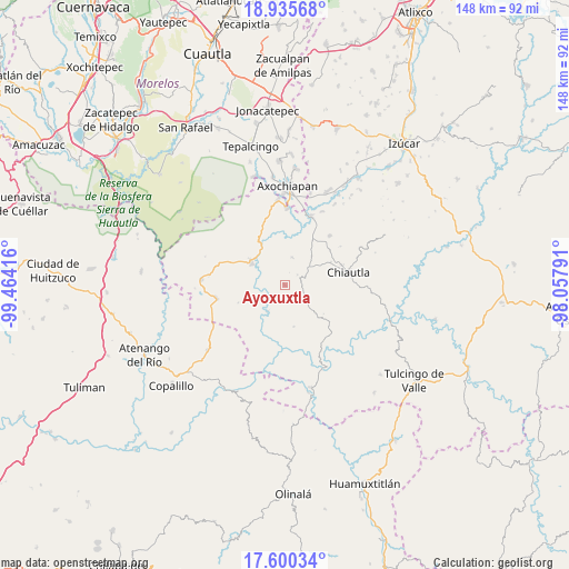
Ayoxuxtla GPS coordinates[2]
18° 16' 9.444" North, 98° 45' 39.708" West
| Map corner | latitude | longitude |
|---|---|---|
| Upper-left | 18.93568°, | -99.46416° |
| Center: | 18.26929°, | -98.76103° |
| Lower-right: | 17.60034°, | -98.05791° |
| Map W x H: | 148.5×148.5 km | = 92.3×92.3mi |
| max Lat: | 32.7° ⇑75.3% North |
| Ayoxuxtla: | 18.26929° |
| min Lat: | ⇓24.7% South 14.53588° |
| min Long | Ayoxuxtla | max Long |
| -117.105° | -98.76103° | -86.73105° |
| W 54.2%⇐ | ⇒45.8% E |
Elevation
Elevation of Ayoxuxtla is 1017 m = 3337 ft, and this is 236.7 m = 777 ft below average elevation for this country.
| Max E: |
3497 m = 11473 ft | 59.7% |
| Avg. | 1253.7 m = 4113 ft | |
| Ayoxuxtla | 1017 m = 3337 ft | |
Min E: |
-1 m = -3 ft | 40.3% |
See also: Mexico elevation on elevation.city.
Geographical zone
Ayoxuxtla is located in North Torrid zone (between Equator and Tropic of Cancer). Distance of this Northern Tropic circle is 574.6 km =357 mi to North.| Distance of | km | miles | from Ayoxuxtla |
|---|---|---|---|
| North Pole | 7975.7 | 4955.9 | to North |
| Arctic Circle | 5369.8 | 3336.6 | to North |
| Tropic Cancer | 574.6 | 357 | to North |
| Equator | 2031.4 | 1262.3 | to South |


Nearby cities:
15 places around Ayoxuxtla: (largest is in red/bold)
• Chiautla de Tapia
17 km =10.6 mi,  77°
77°
• Ciudad de Chiautla de Tapia
16.9 km =10.5 mi, 78°
• Coacalco
24.1 km =15 mi,  155°
155°
• Huachinantla
21.9 km =13.6 mi,  273°
273°
• Huehuetlan el Chico
13.8 km =8.6 mi,  32°
32°
• Jolalpan
10.8 km =6.7 mi,  304°
304°
• Pilcaya (San Juan Pilcaya)
6.7 km =4.2 mi,  122°
122°
• San Miguel Tecolacio
21.6 km =13.4 mi, 27°
• Santa Ana Tecolapa
17.4 km =10.8 mi,  41°
41°
• Santa Mónica
8.1 km =5 mi,  213°
213°
• Teotlalco
22.3 km =13.9 mi,  355°
355°
• Teutla
19.9 km =12.4 mi,  276°
276°
• Tlancualpican
19.3 km =12 mi,  19°
19°
• Tzicatlán
20.2 km =12.6 mi,  1°
1°
• Xochitepec
13 km =8.1 mi,  249°
249°
Sources, notices
• [Note1] Compared only with cities in Mexico existing in our database
• [Src1] Map data: © OpenStreetMap contributors (CC-BY-SA)
• [Src2] Other city data from geonames.org with taken over terms of usage.
• [Src3] Geographical zone / Annual Mean Temperature by Robert A. Rohde @ Wikipedia
