San Miguel de las Palmas geodata
San Miguel de las Palmas (Guerrero) is a populated place; located in Mexico in America/Mexico_City (GMT-6) time zone. With population of 1,194 people, there are 7274 cities with bigger population in this country. Compared to other cities in Mexico, 75.5% of cities are located further ↑North; 52.8% of cities are located further →East and 56.2% of cities have higher elevation than San Miguel de las Palmas. Note1
Current local time in San Miguel de las Palmas:
06:48 AM, WednesdayDifference from your time zone: hours


San Miguel de las Palmas GPS coordinates[2]
18° 15' 7.308" North, 99° 12' 2.916" West
| Map corner | latitude | longitude |
|---|---|---|
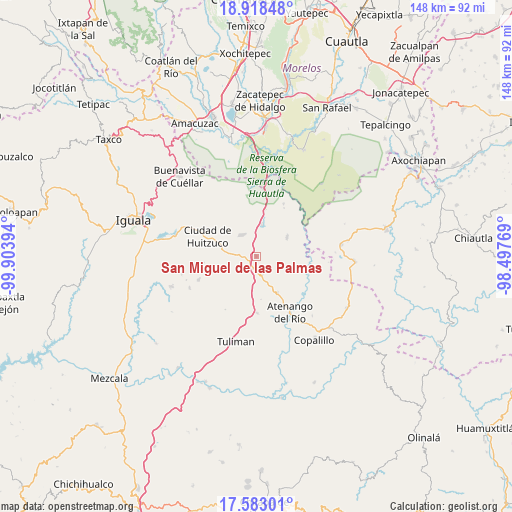
| Upper-left | 18.91848°, | -99.90394° |
| Center: | 18.25203°, | -99.20081° |
| Lower-right: | 17.58301°, | -98.49769° |
| Map W x H: | 148.5×148.5 km | = 92.3×92.3mi |
| max Lat: | 32.7° ⇑75.5% North |
| San Miguel de las Palmas: | 18.25203° |
| min Lat: | ⇓24.5% South 14.53588° |
| min Long | San Miguel de l | max Long |
| -117.105° | -99.20081° | -86.73105° |
| W 47.2%⇐ | ⇒52.8% E |
Elevation
Elevation of San Miguel de las Palmas is 1153 m = 3783 ft, and this is 100.7 m = 330 ft below average elevation for this country.
| Max E: |
3497 m = 11473 ft | 56.2% |
| Avg. | 1253.7 m = 4113 ft | |
| San Miguel de las Palmas | 1153 m = 3783 ft | |
Min E: |
-1 m = -3 ft | 43.8% |
See also: Mexico elevation on elevation.city.
Geographical zone
San Miguel de las Palmas is located in North Torrid zone (between Equator and Tropic of Cancer). Distance of this Northern Tropic circle is 576.5 km =358.2 mi to North.| Distance of | km | miles | from San Miguel de las Palmas |
|---|---|---|---|
| North Pole | 7977.6 | 4957 | to North |
| Arctic Circle | 5371.7 | 3337.8 | to North |
| Tropic Cancer | 576.5 | 358.2 | to North |
| Equator | 2029.4 | 1261 | to South |


Nearby cities:
15 places around San Miguel de las Palmas: (largest is in red/bold)
• Apanguito
12.1 km =7.5 mi,  149°
149°
• Atenango del Río
19.1 km =11.9 mi, 148°
• Atetetla
20 km =12.4 mi,  295°
295°
• Cacahuananche
17.9 km =11.1 mi,  247°
247°
• Chaucingo
10.5 km =6.5 mi,  59°
59°
• Ciudad de Huitzuco
15.2 km =9.4 mi,  292°
292°
• Escuchapa
7.6 km =4.7 mi,  323°
323°
• Lagunillas
10.9 km =6.8 mi, 249°
• Paso Morelos
3.6 km =2.2 mi,  195°
195°
• Pololcingo
20.5 km =12.7 mi,  279°
279°
• Quetzalapa
9.3 km =5.8 mi,  8°
8°
• San Juan Teocalcingo
17.2 km =10.7 mi,  27°
27°
• Tequicuilco
16.5 km =10.3 mi,  179°
179°
• Tlapala
15.5 km =9.6 mi,  262°
262°
• Xilocintla
21.3 km =13.2 mi,  244°
244°
Sources, notices
• [Note1] Compared only with cities in Mexico existing in our database
• [Src1] Map data: © OpenStreetMap contributors (CC-BY-SA)
• [Src2] Other city data from geonames.org with taken over terms of usage.
• [Src3] Geographical zone / Annual Mean Temperature by Robert A. Rohde @ Wikipedia
