Huachinantla geodata
Huachinantla (Puebla) is a populated place; located in Mexico in America/Mexico_City (GMT-6) time zone. With population of 1,465 people, there are 5899 cities with bigger population in this country. Compared to other cities in Mexico, 75.1% of cities are located further ↑North; 50.7% of cities are located further ←West and 62.3% of cities have higher elevation than Huachinantla. Note1


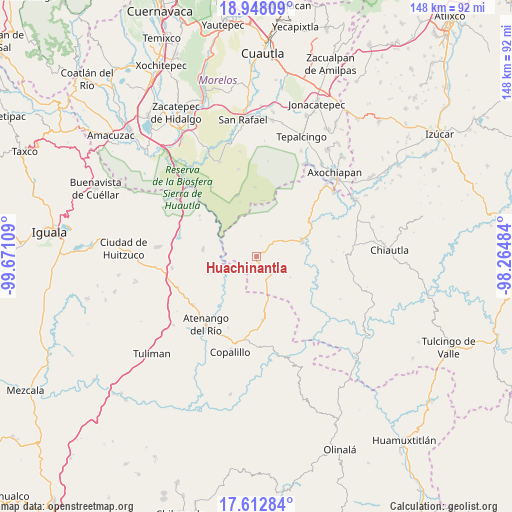
Huachinantla GPS coordinates[2]
18° 16' 54.3" North, 98° 58' 4.656" West
| Map corner | latitude | longitude |
|---|---|---|
| Upper-left | 18.94809°, | -99.67109° |
| Center: | 18.28175°, | -98.96796° |
| Lower-right: | 17.61284°, | -98.26484° |
| Map W x H: | 148.5×148.5 km | = 92.3×92.3mi |
| max Lat: | 32.7° ⇑75.1% North |
| Huachinantla: | 18.28175° |
| min Lat: | ⇓24.9% South 14.53588° |
| min Long | Huachinantla | max Long |
| -117.105° | -98.96796° | -86.73105° |
| W 50.7%⇐ | ⇒49.3% E |
Elevation
Elevation of Huachinantla is 867 m = 2844 ft, and this is 386.7 m = 1269 ft below average elevation for this country.
| Max E: |
3497 m = 11473 ft | 62.3% |
| Avg. | 1253.7 m = 4113 ft | |
| Huachinantla | 867 m = 2844 ft | |
Min E: |
-1 m = -3 ft | 37.7% |
See also: Mexico elevation on elevation.city.
Geographical zone
Huachinantla is located in North Torrid zone (between Equator and Tropic of Cancer). Distance of this Northern Tropic circle is 573.2 km =356.2 mi to North.| Distance of | km | miles | from Huachinantla |
|---|---|---|---|
| North Pole | 7974.3 | 4955 | to North |
| Arctic Circle | 5368.4 | 3335.8 | to North |
| Tropic Cancer | 573.2 | 356.2 | to North |
| Equator | 2032.7 | 1263.1 | to South |


Nearby cities:
15 places around Huachinantla: (largest is in red/bold)
• Apanguito
23 km =14.3 mi,  233°
233°
• Atenango del Río
24.6 km =15.3 mi,  216°
216°
• Ayoxuxtla
21.9 km =13.6 mi,  93°
93°
• Chaucingo
15.7 km =9.8 mi,  277°
277°
• El Cascalote
22.1 km =13.7 mi,  201°
201°
• Huautla
18.6 km =11.6 mi,  341°
341°
• Jolalpan
13.9 km =8.6 mi,  69°
69°
• Quetzalapa
23.9 km =14.9 mi, 284°
• Quilamula
26 km =16.2 mi,  348°
348°
• San Juan Teocalcingo
20.4 km =12.7 mi,  305°
305°
• San Miguel de las Palmas
24.8 km =15.4 mi,  262°
262°
• Santa Mónica
19.2 km =11.9 mi,  115°
115°
• Temalac de Morelos
18.4 km =11.4 mi,  175°
175°
• Teutla
2.3 km =1.4 mi, 66°
• Xochitepec
11.4 km =7.1 mi, 121°
Sources, notices
• [Note1] Compared only with cities in Mexico existing in our database
• [Src1] Map data: © OpenStreetMap contributors (CC-BY-SA)
• [Src2] Other city data from geonames.org with taken over terms of usage.
• [Src3] Geographical zone / Annual Mean Temperature by Robert A. Rohde @ Wikipedia
