Quetzalapa geodata
Quetzalapa (Guerrero) is a populated place; located in Mexico in America/Mexico_City (GMT-6) time zone. With population of 848 people, there are 10316 cities with bigger population in this country. Compared to other cities in Mexico, 74.5% of cities are located further ↑North; 52.5% of cities are located further →East and 61.3% of cities have higher elevation than Quetzalapa. Note1


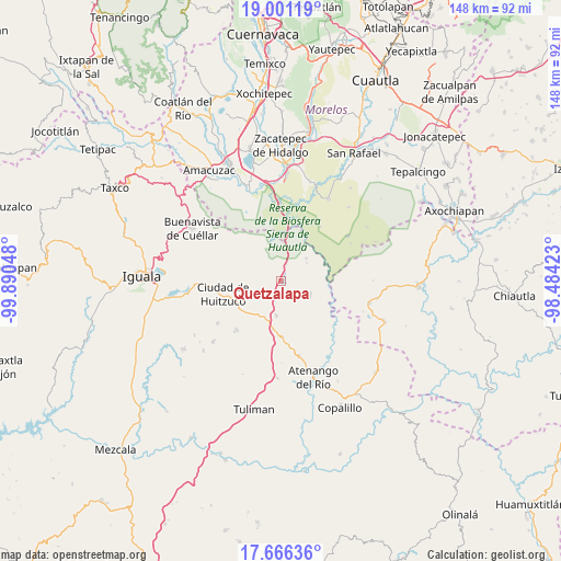
Quetzalapa GPS coordinates[2]
18° 20' 6.216" North, 99° 11' 14.46" West
| Map corner | latitude | longitude |
|---|---|---|
| Upper-left | 19.00119°, | -99.89048° |
| Center: | 18.33506°, | -99.18735° |
| Lower-right: | 17.66636°, | -98.48423° |
| Map W x H: | 148.4×148.4 km | = 92.2×92.2mi |
| max Lat: | 32.7° ⇑74.5% North |
| Quetzalapa: | 18.33506° |
| min Lat: | ⇓25.5% South 14.53588° |
| min Long | Quetzalapa | max Long |
| -117.105° | -99.18735° | -86.73105° |
| W 47.5%⇐ | ⇒52.5% E |
Elevation
Elevation of Quetzalapa is 919 m = 3015 ft, and this is 334.7 m = 1098 ft below average elevation for this country.
| Max E: |
3497 m = 11473 ft | 61.3% |
| Avg. | 1253.7 m = 4113 ft | |
| Quetzalapa | 919 m = 3015 ft | |
Min E: |
-1 m = -3 ft | 38.7% |
See also: Mexico elevation on elevation.city.
Geographical zone
Quetzalapa is located in North Torrid zone (between Equator and Tropic of Cancer). Distance of this Northern Tropic circle is 567.3 km =352.5 mi to North.| Distance of | km | miles | from Quetzalapa |
|---|---|---|---|
| North Pole | 7968.4 | 4951.3 | to North |
| Arctic Circle | 5362.5 | 3332.1 | to North |
| Tropic Cancer | 567.3 | 352.5 | to North |
| Equator | 2038.7 | 1266.8 | to South |


Nearby cities:
15 places around Quetzalapa: (largest is in red/bold)
• Apanguito
20.2 km =12.6 mi,  166°
166°
• Atetetla
19.6 km =12.2 mi,  267°
267°
• Chaucingo
8.5 km =5.3 mi,  116°
116°
• Ciudad de Huitzuco
15.9 km =9.9 mi,  257°
257°
• Escuchapa
6.7 km =4.2 mi,  242°
242°
• Huachinantla
23.9 km =14.9 mi,  104°
104°
• Huautla
20.8 km =12.9 mi,  55°
55°
• Lagunillas
17.5 km =10.9 mi,  221°
221°
• Paso Morelos
12.9 km =8 mi,  190°
190°
• Pololcingo
22.5 km =14 mi,  254°
254°
• San Juan Teocalcingo
8.9 km =5.5 mi,  47°
47°
• San Miguel de las Palmas
9.3 km =5.8 mi, 188°
• San Vicente Palapa
23.6 km =14.7 mi, 267°
• Tilzapotla
19.4 km =12.1 mi,  331°
331°
• Tlapala
20.2 km =12.6 mi, 236°
Sources, notices
• [Note1] Compared only with cities in Mexico existing in our database
• [Src1] Map data: © OpenStreetMap contributors (CC-BY-SA)
• [Src2] Other city data from geonames.org with taken over terms of usage.
• [Src3] Geographical zone / Annual Mean Temperature by Robert A. Rohde @ Wikipedia
