Acalmani geodata
Acalmani (Guerrero) is a populated place; located in Mexico in America/Mexico_City (GMT-6) time zone. With population of 940 people, there are 9266 cities with bigger population in this country. Compared to other cities in Mexico, 87.8% of cities are located further ↑North; 51.4% of cities are located further →East and 59.6% of cities have higher elevation than Acalmani. Note1


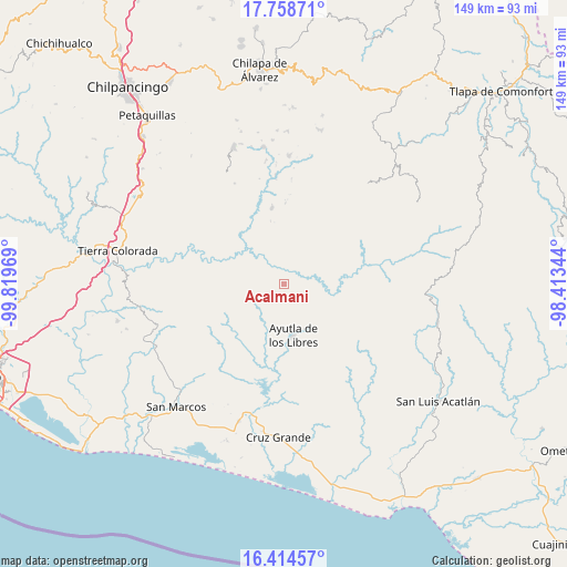
Acalmani GPS coordinates[2]
17° 5' 16.26" North, 99° 6' 59.616" West
| Map corner | latitude | longitude |
|---|---|---|
| Upper-left | 17.75871°, | -99.81969° |
| Center: | 17.08785°, | -99.11656° |
| Lower-right: | 16.41457°, | -98.41344° |
| Map W x H: | 149.5×149.5 km | = 92.9×92.9mi |
| max Lat: | 32.7° ⇑87.8% North |
| Acalmani: | 17.08785° |
| min Lat: | ⇓12.2% South 14.53588° |
| min Long | Acalmani | max Long |
| -117.105° | -99.11656° | -86.73105° |
| W 48.6%⇐ | ⇒51.4% E |
Elevation
Elevation of Acalmani is 1020 m = 3346 ft, and this is 233.7 m = 767 ft below average elevation for this country.
| Max E: |
3497 m = 11473 ft | 59.6% |
| Avg. | 1253.7 m = 4113 ft | |
| Acalmani | 1020 m = 3346 ft | |
Min E: |
-1 m = -3 ft | 40.4% |
See also: Mexico elevation on elevation.city.
Geographical zone
Acalmani is located in North Torrid zone (between Equator and Tropic of Cancer). Distance of this Northern Tropic circle is 705.9 km =438.6 mi to North.| Distance of | km | miles | from Acalmani |
|---|---|---|---|
| North Pole | 8107.1 | 5037.5 | to North |
| Arctic Circle | 5501.2 | 3418.3 | to North |
| Tropic Cancer | 705.9 | 438.6 | to North |
| Equator | 1900 | 1180.6 | to South |


Nearby cities:
15 places around Acalmani: (largest is in red/bold)
• Apantla
7.8 km =4.8 mi,  226°
226°
• Ayutla de los Libres
14 km =8.7 mi,  171°
171°
• Buenavista de Allende
14.1 km =8.8 mi, 226°
• Camalote
14.4 km =8.9 mi,  100°
100°
• Colotepec
11.5 km =7.1 mi,  243°
243°
• Cruz Quemada
12.1 km =7.5 mi,  213°
213°
• El Cortijo
11.4 km =7.1 mi,  197°
197°
• El Refugio
10.5 km =6.5 mi, 238°
• El Salto
9.1 km =5.7 mi,  128°
128°
• Lagunillas
11.6 km =7.2 mi, 225°
• Los Tepetates
14.3 km =8.9 mi,  256°
256°
• Plan de Gatica
4.7 km =2.9 mi,  354°
354°
• San José la Hacienda
13.2 km =8.2 mi,  156°
156°
• Tecruz
8.6 km =5.3 mi,  109°
109°
• Tierra Blanca
8.9 km =5.5 mi,  36°
36°
Sources, notices
• [Note1] Compared only with cities in Mexico existing in our database
• [Src1] Map data: © OpenStreetMap contributors (CC-BY-SA)
• [Src2] Other city data from geonames.org with taken over terms of usage.
• [Src3] Geographical zone / Annual Mean Temperature by Robert A. Rohde @ Wikipedia
