Cruz Quemada geodata
Cruz Quemada (Guerrero) is a populated place; located in Mexico in America/Mexico_City (GMT-6) time zone. With population of 1,694 people, there are 5127 cities with bigger population in this country. Compared to other cities in Mexico, 88.9% of cities are located further ↑North; 52.4% of cities are located further →East and 70.8% of cities have higher elevation than Cruz Quemada. Note1


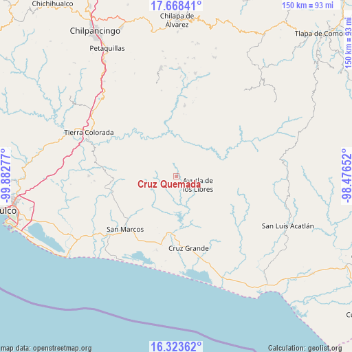
Cruz Quemada GPS coordinates[2]
16° 59' 49.992" North, 99° 10' 46.704" West
| Map corner | latitude | longitude |
|---|---|---|
| Upper-left | 17.66841°, | -99.88277° |
| Center: | 16.99722°, | -99.17964° |
| Lower-right: | 16.32362°, | -98.47652° |
| Map W x H: | 149.5×149.5 km | = 92.9×92.9mi |
| max Lat: | 32.7° ⇑88.9% North |
| Cruz Quemada: | 16.99722° |
| min Lat: | ⇓11.1% South 14.53588° |
| min Long | Cruz Quemada | max Long |
| -117.105° | -99.17964° | -86.73105° |
| W 47.6%⇐ | ⇒52.4% E |
Elevation
Elevation of Cruz Quemada is 378 m = 1240 ft, and this is 875.7 m = 2873 ft below average elevation for this country.
| Max E: |
3497 m = 11473 ft | 70.8% |
| Avg. | 1253.7 m = 4113 ft | |
| Cruz Quemada | 378 m = 1240 ft | |
Min E: |
-1 m = -3 ft | 29.2% |
See also: Mexico elevation on elevation.city.
Geographical zone
Cruz Quemada is located in North Torrid zone (between Equator and Tropic of Cancer). Distance of this Northern Tropic circle is 716 km =444.9 mi to North.| Distance of | km | miles | from Cruz Quemada |
|---|---|---|---|
| North Pole | 8117.1 | 5043.7 | to North |
| Arctic Circle | 5511.3 | 3424.6 | to North |
| Tropic Cancer | 716 | 444.9 | to North |
| Equator | 1889.9 | 1174.3 | to South |


Nearby cities:
15 places around Cruz Quemada: (largest is in red/bold)
• Apantla
4.8 km =3 mi,  12°
12°
• Ayutla de los Libres
9.6 km =6 mi,  112°
112°
• Buenavista de Allende
3.6 km =2.2 mi,  276°
276°
• Colotepec
6 km =3.7 mi,  324°
324°
• El Carrizo
9.3 km =5.8 mi,  208°
208°
• El Cortijo
3.4 km =2.1 mi,  104°
104°
• El Guayabo
7 km =4.3 mi,  204°
204°
• El Refugio
5.1 km =3.2 mi,  334°
334°
• Lagunillas
2.6 km =1.6 mi, 320°
• Los Tepetates
9.9 km =6.2 mi,  313°
313°
• Mecatepec
6.3 km =3.9 mi,  256°
256°
• Parota Seca
10.6 km =6.6 mi,  233°
233°
• Tecoanapa
8.6 km =5.3 mi, 262°
• Tecuantepec
7.3 km =4.5 mi,  272°
272°
• Tutepec
8.8 km =5.5 mi,  163°
163°
Sources, notices
• [Note1] Compared only with cities in Mexico existing in our database
• [Src1] Map data: © OpenStreetMap contributors (CC-BY-SA)
• [Src2] Other city data from geonames.org with taken over terms of usage.
• [Src3] Geographical zone / Annual Mean Temperature by Robert A. Rohde @ Wikipedia
