Plan de Gatica geodata
Plan de Gatica (Guerrero) is a populated place; located in Mexico in America/Mexico_City (GMT-6) time zone. With population of 959 people, there are 9077 cities with bigger population in this country. Compared to other cities in Mexico, 87.4% of cities are located further ↑North; 51.5% of cities are located further →East and 67.1% of cities have higher elevation than Plan de Gatica. Note1


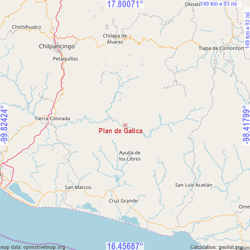
Plan de Gatica GPS coordinates[2]
17° 7' 48" North, 99° 7' 15.996" West
| Map corner | latitude | longitude |
|---|---|---|
| Upper-left | 17.80071°, | -99.82424° |
| Center: | 17.13°, | -99.12111° |
| Lower-right: | 16.45687°, | -98.41799° |
| Map W x H: | 149.4×149.4 km | = 92.8×92.8mi |
| max Lat: | 32.7° ⇑87.4% North |
| Plan de Gatica: | 17.13° |
| min Lat: | ⇓12.6% South 14.53588° |
| min Long | Plan de Gatica | max Long |
| -117.105° | -99.12111° | -86.73105° |
| W 48.5%⇐ | ⇒51.5% E |
Elevation
Elevation of Plan de Gatica is 579 m = 1900 ft, and this is 674.7 m = 2214 ft below average elevation for this country.
| Max E: |
3497 m = 11473 ft | 67.1% |
| Avg. | 1253.7 m = 4113 ft | |
| Plan de Gatica | 579 m = 1900 ft | |
Min E: |
-1 m = -3 ft | 32.9% |
See also: Mexico elevation on elevation.city.
Geographical zone
Plan de Gatica is located in North Torrid zone (between Equator and Tropic of Cancer). Distance of this Northern Tropic circle is 701.2 km =435.7 mi to North.| Distance of | km | miles | from Plan de Gatica |
|---|---|---|---|
| North Pole | 8102.4 | 5034.6 | to North |
| Arctic Circle | 5496.5 | 3415.4 | to North |
| Tropic Cancer | 701.2 | 435.7 | to North |
| Equator | 1904.7 | 1183.5 | to South |


Nearby cities:
15 places around Plan de Gatica: (largest is in red/bold)
• Acalmani
4.7 km =2.9 mi,  174°
174°
• Apantla
11.3 km =7 mi,  207°
207°
• Colotepec
13.9 km =8.6 mi,  224°
224°
• Cruz Quemada
16 km =9.9 mi,  202°
202°
• El Cortijo
15.9 km =9.9 mi,  190°
190°
• El Refugio
13.2 km =8.2 mi, 219°
• El Salto
12.8 km =8 mi,  143°
143°
• El Tejoruco
12.2 km =7.6 mi,  359°
359°
• Lagunillas
15 km =9.3 mi, 211°
• Los Tepetates
15.6 km =9.7 mi,  239°
239°
• San José
16.3 km =10.1 mi,  2°
2°
• Tecruz
11.4 km =7.1 mi,  131°
131°
• Teozintla
15.9 km =9.9 mi,  350°
350°
• Tierra Blanca
6.3 km =3.9 mi,  66°
66°
• Xochitepec
12.6 km =7.8 mi,  297°
297°
Sources, notices
• [Note1] Compared only with cities in Mexico existing in our database
• [Src1] Map data: © OpenStreetMap contributors (CC-BY-SA)
• [Src2] Other city data from geonames.org with taken over terms of usage.
• [Src3] Geographical zone / Annual Mean Temperature by Robert A. Rohde @ Wikipedia
