El Salto geodata
El Salto (Guerrero) is a populated place; located in Mexico in America/Mexico_City (GMT-6) time zone. With population of 547 people, there are 15556 cities with bigger population in this country. Compared to other cities in Mexico, 88.4% of cities are located further ↑North; 50.5% of cities are located further →East and 60.4% of cities have higher elevation than El Salto. Note1


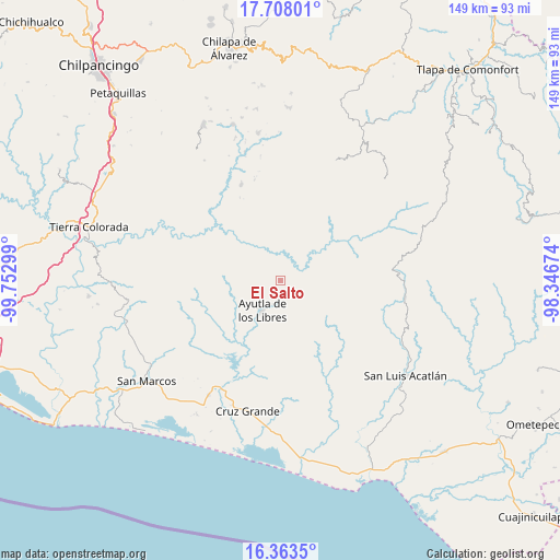
El Salto GPS coordinates[2]
17° 2' 13.056" North, 99° 2' 59.496" West
| Map corner | latitude | longitude |
|---|---|---|
| Upper-left | 17.70801°, | -99.75299° |
| Center: | 17.03696°, | -99.04986° |
| Lower-right: | 16.3635°, | -98.34674° |
| Map W x H: | 149.5×149.5 km | = 92.9×92.9mi |
| max Lat: | 32.7° ⇑88.4% North |
| El Salto: | 17.03696° |
| min Lat: | ⇓11.6% South 14.53588° |
| min Long | El Salto | max Long |
| -117.105° | -99.04986° | -86.73105° |
| W 49.5%⇐ | ⇒50.5% E |
Elevation
Elevation of El Salto is 974 m = 3196 ft, and this is 279.7 m = 918 ft below average elevation for this country.
| Max E: |
3497 m = 11473 ft | 60.4% |
| Avg. | 1253.7 m = 4113 ft | |
| El Salto | 974 m = 3196 ft | |
Min E: |
-1 m = -3 ft | 39.6% |
See also: Mexico elevation on elevation.city.
Geographical zone
El Salto is located in North Torrid zone (between Equator and Tropic of Cancer). Distance of this Northern Tropic circle is 711.6 km =442.2 mi to North.| Distance of | km | miles | from El Salto |
|---|---|---|---|
| North Pole | 8112.7 | 5041 | to North |
| Arctic Circle | 5506.8 | 3421.8 | to North |
| Tropic Cancer | 711.6 | 442.2 | to North |
| Equator | 1894.3 | 1177.1 | to South |


Nearby cities:
15 places around El Salto: (largest is in red/bold)
• Acalmani
9.1 km =5.7 mi,  308°
308°
• Apantla
12.7 km =7.9 mi,  271°
271°
• Ayutla de los Libres
9.5 km =5.9 mi,  211°
211°
• Camalote
7.7 km =4.8 mi,  67°
67°
• Caxitepec
13.6 km =8.5 mi,  54°
54°
• Ciénega del Sauce
10.9 km =6.8 mi,  92°
92°
• Cotzalzin
13.8 km =8.6 mi,  202°
202°
• Cruz Quemada
14.5 km =9 mi,  252°
252°
• El Cortijo
11.8 km =7.3 mi,  243°
243°
• El Paraíso
12.8 km =8 mi,  155°
155°
• Plan de Gatica
12.8 km =8 mi,  323°
323°
• San José la Hacienda
6.6 km =4.1 mi, 195°
• Tecruz
2.9 km =1.8 mi,  19°
19°
• Tierra Blanca
12.9 km =8 mi,  352°
352°
• Tres Cruces
13.3 km =8.3 mi,  99°
99°
Sources, notices
• [Note1] Compared only with cities in Mexico existing in our database
• [Src1] Map data: © OpenStreetMap contributors (CC-BY-SA)
• [Src2] Other city data from geonames.org with taken over terms of usage.
• [Src3] Geographical zone / Annual Mean Temperature by Robert A. Rohde @ Wikipedia
