La Dicha geodata
La Dicha (Guerrero) is a populated place; located in Mexico in America/Mexico_City (GMT-6) time zone. With population of 1,204 people, there are 7219 cities with bigger population in this country. Compared to other cities in Mexico, 92.1% of cities are located further ↑North; 50% of cities are located further ←West and 71.8% of cities have higher elevation than La Dicha. Note1


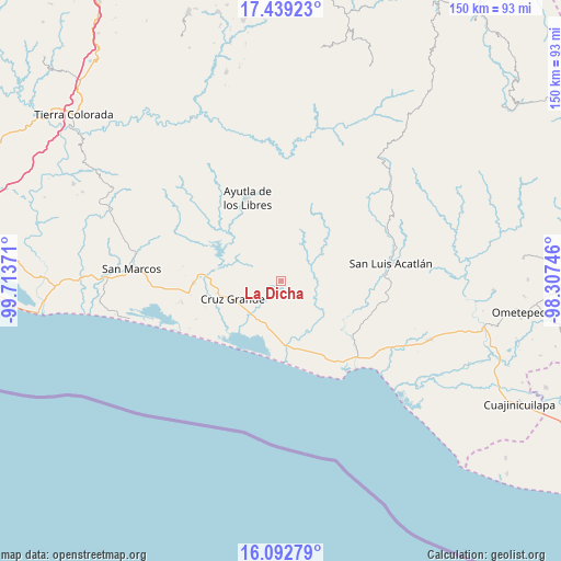
La Dicha GPS coordinates[2]
16° 46' 1.92" North, 99° 0' 38.088" West
| Map corner | latitude | longitude |
|---|---|---|
| Upper-left | 17.43923°, | -99.71371° |
| Center: | 16.7672°, | -99.01058° |
| Lower-right: | 16.09279°, | -98.30746° |
| Map W x H: | 149.7×149.7 km | = 93×93mi |
| max Lat: | 32.7° ⇑92.1% North |
| La Dicha: | 16.7672° |
| min Lat: | ⇓7.9% South 14.53588° |
| min Long | La Dicha | max Long |
| -117.105° | -99.01058° | -86.73105° |
| W 50%⇐ | ⇒50% E |
Elevation
Elevation of La Dicha is 336 m = 1102 ft, and this is 917.7 m = 3011 ft below average elevation for this country.
| Max E: |
3497 m = 11473 ft | 71.8% |
| Avg. | 1253.7 m = 4113 ft | |
| La Dicha | 336 m = 1102 ft | |
Min E: |
-1 m = -3 ft | 28.2% |
See also: Mexico elevation on elevation.city.
Geographical zone
La Dicha is located in North Torrid zone (between Equator and Tropic of Cancer). Distance of this Northern Tropic circle is 741.6 km =460.8 mi to North.| Distance of | km | miles | from La Dicha |
|---|---|---|---|
| North Pole | 8142.7 | 5059.6 | to North |
| Arctic Circle | 5536.8 | 3440.4 | to North |
| Tropic Cancer | 741.6 | 460.8 | to North |
| Equator | 1864.3 | 1158.4 | to South |


Nearby cities:
15 places around La Dicha: (largest is in red/bold)
• Ahuacachahue (Ndog'yo Itún Tichi)
7.3 km =4.5 mi,  21°
21°
• Coacoyulichán
8.6 km =5.3 mi,  68°
68°
• Cuautepec
2.1 km =1.3 mi,  155°
155°
• El Coquillo
9.6 km =6 mi,  118°
118°
• El Llano
9.8 km =6.1 mi,  141°
141°
• El Mesón
10.1 km =6.3 mi,  329°
329°
• El Pabellón
10 km =6.2 mi,  183°
183°
• El Salto
9.3 km =5.8 mi,  170°
170°
• El Zapote
11.6 km =7.2 mi,  310°
310°
• Huamuchititán (El Huamuchito)
6.2 km =3.9 mi,  111°
111°
• Jalapa
7.8 km =4.8 mi,  218°
218°
• La Azozuca
6.9 km =4.3 mi, 331°
• Mesón Zapote
11.3 km =7 mi, 24°
• Poza Verde
11.7 km =7.3 mi, 69°
• Tonalá
11.5 km =7.1 mi,  336°
336°
Sources, notices
• [Note1] Compared only with cities in Mexico existing in our database
• [Src1] Map data: © OpenStreetMap contributors (CC-BY-SA)
• [Src2] Other city data from geonames.org with taken over terms of usage.
• [Src3] Geographical zone / Annual Mean Temperature by Robert A. Rohde @ Wikipedia
