El Pabellón geodata
El Pabellón (Guerrero) is a populated place; located in Mexico in America/Mexico_City (GMT-6) time zone. With population of 862 people, there are 10147 cities with bigger population in this country. Compared to other cities in Mexico, 93% of cities are located further ↑North; 50.1% of cities are located further →East and 82.1% of cities have higher elevation than El Pabellón. Note1


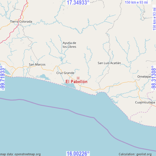
El Pabellón GPS coordinates[2]
16° 40' 37.128" North, 99° 0' 58.32" West
| Map corner | latitude | longitude |
|---|---|---|
| Upper-left | 17.34933°, | -99.71933° |
| Center: | 16.67698°, | -99.0162° |
| Lower-right: | 16.00226°, | -98.31308° |
| Map W x H: | 149.8×149.8 km | = 93.1×93.1mi |
| max Lat: | 32.7° ⇑93% North |
| El Pabellón: | 16.67698° |
| min Lat: | ⇓7% South 14.53588° |
| min Long | El Pabellón | max Long |
| -117.105° | -99.0162° | -86.73105° |
| W 49.9%⇐ | ⇒50.1% E |
Elevation
Elevation of El Pabellón is 69 m = 226 ft, and this is 1184.7 m = 3887 ft below average elevation for this country.
| Max E: |
3497 m = 11473 ft | 82.1% |
| Avg. | 1253.7 m = 4113 ft | |
| El Pabellón | 69 m = 226 ft | |
Min E: |
-1 m = -3 ft | 17.9% |
See also: Mexico elevation on elevation.city.
Geographical zone
El Pabellón is located in North Torrid zone (between Equator and Tropic of Cancer). Distance of this Northern Tropic circle is 751.6 km =467 mi to North.| Distance of | km | miles | from El Pabellón |
|---|---|---|---|
| North Pole | 8152.8 | 5065.9 | to North |
| Arctic Circle | 5546.9 | 3446.7 | to North |
| Tropic Cancer | 751.6 | 467 | to North |
| Equator | 1854.3 | 1152.2 | to South |


Nearby cities:
15 places around El Pabellón: (largest is in red/bold)
• Atrixco
9.8 km =6.1 mi,  118°
118°
• Chautengo
8.9 km =5.5 mi,  244°
244°
• Coacoyulichán
15.7 km =9.8 mi,  33°
33°
• Copala
8.7 km =5.4 mi,  152°
152°
• Cruz Grande
12.5 km =7.8 mi,  293°
293°
• Cuautepec
8.3 km =5.2 mi,  10°
10°
• El Carrizo
4.5 km =2.8 mi,  195°
195°
• El Coquillo
10.6 km =6.6 mi,  58°
58°
• El Llano
7.1 km =4.4 mi,  70°
70°
• El Salto
2.3 km =1.4 mi, 68°
• Huamuchititán (El Huamuchito)
10 km =6.2 mi,  39°
39°
• Jalapa
5.7 km =3.5 mi,  313°
313°
• La Dicha
10 km =6.2 mi,  3°
3°
• Las Peñas
6.6 km =4.1 mi,  223°
223°
• Pico del Monte
13.5 km =8.4 mi, 236°
Sources, notices
• [Note1] Compared only with cities in Mexico existing in our database
• [Src1] Map data: © OpenStreetMap contributors (CC-BY-SA)
• [Src2] Other city data from geonames.org with taken over terms of usage.
• [Src3] Geographical zone / Annual Mean Temperature by Robert A. Rohde @ Wikipedia
