Coacoyulichán geodata
Coacoyulichán (Guerrero) is a populated place; located in Mexico in America/Mexico_City (GMT-6) time zone. With population of 1,522 people, there are 5665 cities with bigger population in this country. Compared to other cities in Mexico, 91.8% of cities are located further ↑North; 51.3% of cities are located further ←West and 70.2% of cities have higher elevation than Coacoyulichán. Note1


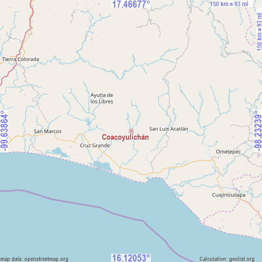
Coacoyulichán GPS coordinates[2]
16° 47' 41.424" North, 98° 56' 7.836" West
| Map corner | latitude | longitude |
|---|---|---|
| Upper-left | 17.46677°, | -99.63864° |
| Center: | 16.79484°, | -98.93551° |
| Lower-right: | 16.12053°, | -98.23239° |
| Map W x H: | 149.7×149.7 km | = 93×93mi |
| max Lat: | 32.7° ⇑91.8% North |
| Coacoyulichán: | 16.79484° |
| min Lat: | ⇓8.2% South 14.53588° |
| min Long | Coacoyulichán | max Long |
| -117.105° | -98.93551° | -86.73105° |
| W 51.3%⇐ | ⇒48.7% E |
Elevation
Elevation of Coacoyulichán is 409 m = 1342 ft, and this is 844.7 m = 2771 ft below average elevation for this country.
| Max E: |
3497 m = 11473 ft | 70.2% |
| Avg. | 1253.7 m = 4113 ft | |
| Coacoyulichán | 409 m = 1342 ft | |
Min E: |
-1 m = -3 ft | 29.8% |
See also: Mexico elevation on elevation.city.
Geographical zone
Coacoyulichán is located in North Torrid zone (between Equator and Tropic of Cancer). Distance of this Northern Tropic circle is 738.5 km =458.9 mi to North.| Distance of | km | miles | from Coacoyulichán |
|---|---|---|---|
| North Pole | 8139.7 | 5057.8 | to North |
| Arctic Circle | 5533.8 | 3438.5 | to North |
| Tropic Cancer | 738.5 | 458.9 | to North |
| Equator | 1867.4 | 1160.3 | to South |


Nearby cities:
15 places around Coacoyulichán: (largest is in red/bold)
• Ahuacachahue (Ndog'yo Itún Tichi)
6.5 km =4 mi,  305°
305°
• Cuautepec
8.7 km =5.4 mi,  235°
235°
• El Coquillo
7.6 km =4.7 mi,  176°
176°
• El Llano
10.9 km =6.8 mi,  189°
189°
• El Mesón
14.3 km =8.9 mi,  293°
293°
• El Salto
13.8 km =8.6 mi,  207°
207°
• Huamuchititán (El Huamuchito)
5.8 km =3.6 mi,  202°
202°
• La Angostura
13.6 km =8.5 mi, 312°
• La Azozuca
11.7 km =7.3 mi,  284°
284°
• La Concordia
13.1 km =8.1 mi,  340°
340°
• La Dicha
8.6 km =5.3 mi,  248°
248°
• Mesón Zapote
8 km =5 mi, 335°
• Miahuichán
13.5 km =8.4 mi,  85°
85°
• Poza Verde
3.1 km =1.9 mi,  71°
71°
• Tonalá
14.7 km =9.1 mi,  300°
300°
Sources, notices
• [Note1] Compared only with cities in Mexico existing in our database
• [Src1] Map data: © OpenStreetMap contributors (CC-BY-SA)
• [Src2] Other city data from geonames.org with taken over terms of usage.
• [Src3] Geographical zone / Annual Mean Temperature by Robert A. Rohde @ Wikipedia
