El Llano geodata
El Llano (Guerrero) is a populated place; located in Mexico in America/Mexico_City (GMT-6) time zone. With population of 556 people, there are 15345 cities with bigger population in this country. Compared to other cities in Mexico, 92.9% of cities are located further ↑North; 51% of cities are located further ←West and 77.3% of cities have higher elevation than El Llano. Note1


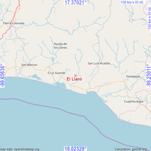
El Llano GPS coordinates[2]
16° 41' 52.584" North, 98° 57' 11.628" West
| Map corner | latitude | longitude |
|---|---|---|
| Upper-left | 17.37021°, | -99.65636° |
| Center: | 16.69794°, | -98.95323° |
| Lower-right: | 16.02329°, | -98.25011° |
| Map W x H: | 149.8×149.8 km | = 93.1×93.1mi |
| max Lat: | 32.7° ⇑92.9% North |
| El Llano: | 16.69794° |
| min Lat: | ⇓7.1% South 14.53588° |
| min Long | El Llano | max Long |
| -117.105° | -98.95323° | -86.73105° |
| W 51%⇐ | ⇒49% E |
Elevation
Elevation of El Llano is 147 m = 482 ft, and this is 1106.7 m = 3631 ft below average elevation for this country.
| Max E: |
3497 m = 11473 ft | 77.3% |
| Avg. | 1253.7 m = 4113 ft | |
| El Llano | 147 m = 482 ft | |
Min E: |
-1 m = -3 ft | 22.7% |
See also: Mexico elevation on elevation.city.
Geographical zone
El Llano is located in North Torrid zone (between Equator and Tropic of Cancer). Distance of this Northern Tropic circle is 749.3 km =465.6 mi to North.| Distance of | km | miles | from El Llano |
|---|---|---|---|
| North Pole | 8150.4 | 5064.4 | to North |
| Arctic Circle | 5544.5 | 3445.2 | to North |
| Tropic Cancer | 749.3 | 465.6 | to North |
| Equator | 1856.6 | 1153.6 | to South |


Nearby cities:
15 places around El Llano: (largest is in red/bold)
• Ahuacachahue (Ndog'yo Itún Tichi)
14.9 km =9.3 mi,  346°
346°
• Atrixco
7.3 km =4.5 mi,  164°
164°
• Coacoyulichán
10.9 km =6.8 mi,  9°
9°
• Copala
10.4 km =6.5 mi,  194°
194°
• Cuautepec
7.8 km =4.8 mi,  317°
317°
• El Carrizo
10.3 km =6.4 mi,  230°
230°
• El Coquillo
3.9 km =2.4 mi,  36°
36°
• El Pabellón
7.1 km =4.4 mi,  250°
250°
• El Salto
4.8 km =3 mi, 252°
• Huamuchititán (El Huamuchito)
5.4 km =3.4 mi,  356°
356°
• Jalapa
11 km =6.8 mi,  278°
278°
• La Dicha
9.8 km =6.1 mi, 321°
• Las Peñas
13.3 km =8.3 mi,  237°
237°
• Poza Verde
12.7 km =7.9 mi,  22°
22°
• Tepantitlán
15.1 km =9.4 mi,  119°
119°
Sources, notices
• [Note1] Compared only with cities in Mexico existing in our database
• [Src1] Map data: © OpenStreetMap contributors (CC-BY-SA)
• [Src2] Other city data from geonames.org with taken over terms of usage.
• [Src3] Geographical zone / Annual Mean Temperature by Robert A. Rohde @ Wikipedia
