Acaxtlahuacán de Albino Zertuche geodata
Acaxtlahuacán de Albino Zertuche (Puebla) is a seat of a second-order administrative division; located in Mexico in America/Mexico_City (GMT-6) time zone. With population of 1,707 people, there are 5091 cities with bigger population in this country. Compared to other cities in Mexico, 78.5% of cities are located further ↑North; 56.7% of cities are located further ←West and 53.4% of cities have higher elevation than Acaxtlahuacán de Albino Zertuche. Note1
Current local time in Acaxtlahuacán de Albino Zertuche:
10:02 AM, MondayDifference from your time zone: hours


Acaxtlahuacán de Albino Zertuche GPS coordinates[2]
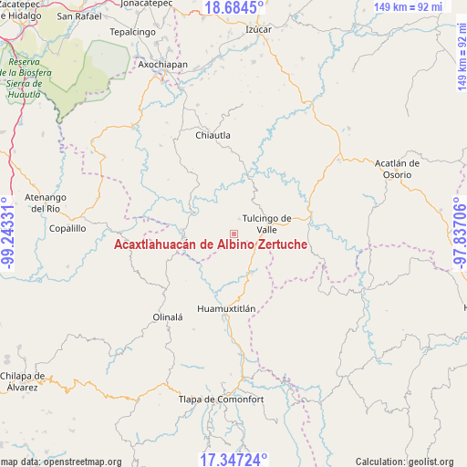
18° 1' 1.704" North, 98° 32' 24.648" West
| Map corner | latitude | longitude |
|---|---|---|
| Upper-left | 18.6845°, | -99.24331° |
| Center: | 18.01714°, | -98.54018° |
| Lower-right: | 17.34724°, | -97.83706° |
| Map W x H: | 148.7×148.7 km | = 92.4×92.4mi |
| max Lat: | 32.7° ⇑78.5% North |
| Acaxtlahuacán de Albino Zertuche: | 18.01714° |
| min Lat: | ⇓21.5% South 14.53588° |
| min Long | Acaxtlahuacán | max Long |
| -117.105° | -98.54018° | -86.73105° |
| W 56.7%⇐ | ⇒43.3% E |
Elevation
Elevation of Acaxtlahuacán de Albino Zertuche is 1273 m = 4177 ft, and this is 19.3 m = 63 ft above average elevation for this country.
| Max E: |
3497 m = 11473 ft | 53.4% |
| Acaxtlahuacán de Albino Zertuche | 1273 m 4177 ft | |
| Avg. | 1253.7 m = 4113 ft | |
Min E: |
-1 m = -3 ft | 46.6% |
See also: Mexico elevation on elevation.city.
Geographical zone
Acaxtlahuacán de Albino Zertuche is located in North Torrid zone (between Equator and Tropic of Cancer). Distance of this Northern Tropic circle is 602.6 km =374.4 mi to North.| Distance of | km | miles | from Acaxtlahuacán de Albino Zertuche |
|---|---|---|---|
| North Pole | 8003.7 | 4973.3 | to North |
| Arctic Circle | 5397.9 | 3354.1 | to North |
| Tropic Cancer | 602.6 | 374.4 | to North |
| Equator | 2003.3 | 1244.8 | to South |


Nearby cities:
15 places around Acaxtlahuacán de Albino Zertuche: (largest is in red/bold)
• Ahuacatlán
22.3 km =13.9 mi,  238°
238°
• Chila de la Sal
11.8 km =7.3 mi,  29°
29°
• Coacalco
14.8 km =9.2 mi,  294°
294°
• Guadalupe Victoria
16.9 km =10.5 mi,  105°
105°
• Ixcamilpa
16.6 km =10.3 mi,  274°
274°
• San Antonio Coyahuacán
22.7 km =14.1 mi,  220°
220°
• San Miguel Comitlipa
5.9 km =3.7 mi,  192°
192°
• San Miguel Tlaltepexi
16.8 km =10.4 mi,  132°
132°
• Santa Cruz Lomalapa (Lomalapa)
17.9 km =11.1 mi,  230°
230°
• Toltecamila
10.3 km =6.4 mi, 233°
• Tulcingo de Valle
10.9 km =6.8 mi,  74°
74°
• Xicotlán
5 km =3.1 mi,  19°
19°
• Xixingo de los Reyes
19.7 km =12.2 mi, 133°
• Xochihuehuetlán
13.5 km =8.4 mi,  155°
155°
• Zumpango
17.6 km =10.9 mi, 238°
Sources, notices
• [Note1] Compared only with cities in Mexico existing in our database
• [Src1] Map data: © OpenStreetMap contributors (CC-BY-SA)
• [Src2] Other city data from geonames.org with taken over terms of usage.
• [Src3] Geographical zone / Annual Mean Temperature by Robert A. Rohde @ Wikipedia
