Cocuilotlazala geodata
Cocuilotlazala (Guerrero) is a populated place; located in Mexico in America/Mexico_City (GMT-6) time zone. With population of 715 people, there are 12184 cities with bigger population in this country. Compared to other cities in Mexico, 85.2% of cities are located further ↑North; 58.3% of cities are located further ←West and 72.7% of cities have lower elevation than Cocuilotlazala. Note1


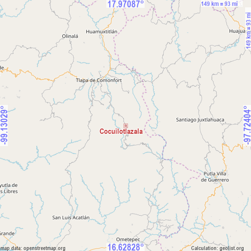
Cocuilotlazala GPS coordinates[2]
17° 18' 2.88" North, 98° 25' 37.776" West
| Map corner | latitude | longitude |
|---|---|---|
| Upper-left | 17.97087°, | -99.13029° |
| Center: | 17.3008°, | -98.42716° |
| Lower-right: | 16.62828°, | -97.72404° |
| Map W x H: | 149.3×149.3 km | = 92.8×92.8mi |
| max Lat: | 32.7° ⇑85.2% North |
| Cocuilotlazala: | 17.3008° |
| min Lat: | ⇓14.8% South 14.53588° |
| min Long | Cocuilotlazala | max Long |
| -117.105° | -98.42716° | -86.73105° |
| W 58.3%⇐ | ⇒41.7% E |
Elevation
Elevation of Cocuilotlazala is 1982 m = 6503 ft, and this is 728.3 m = 2389 ft above average elevation for this country.
| Max E: |
3497 m = 11473 ft | 27.3% |
| Cocuilotlazala | 1982 m 6503 ft | |
| Avg. | 1253.7 m = 4113 ft | |
Min E: |
-1 m = -3 ft | 72.7% |
See also: Mexico elevation on elevation.city.
Geographical zone
Cocuilotlazala is located in North Torrid zone (between Equator and Tropic of Cancer). Distance of this Northern Tropic circle is 682.3 km =424 mi to North.| Distance of | km | miles | from Cocuilotlazala |
|---|---|---|---|
| North Pole | 8083.4 | 5022.8 | to North |
| Arctic Circle | 5477.5 | 3403.6 | to North |
| Tropic Cancer | 682.3 | 424 | to North |
| Equator | 1923.7 | 1195.3 | to South |


Nearby cities:
15 places around Cocuilotlazala: (largest is in red/bold)
• Francisco I. Madero
8.7 km =5.4 mi,  274°
274°
• Huexoapa (San Juan Huexoapa)
5.8 km =3.6 mi,  166°
166°
• Juanacatlán
9.5 km =5.9 mi,  288°
288°
• Lomazóyatl (Lomazoya)
6.9 km =4.3 mi,  329°
329°
• Melchor Ocampo
6.8 km =4.2 mi,  341°
341°
• Metlatónoc
12 km =7.5 mi, 169°
• San Juan Puerto Montaña
10.2 km =6.3 mi,  256°
256°
• San Pablo Atzompa
8.5 km =5.3 mi,  134°
134°
• San Rafael
8.2 km =5.1 mi,  177°
177°
• San Vicente Zoyatlán
7.1 km =4.4 mi,  70°
70°
• Santa Cruz
12 km =7.5 mi,  279°
279°
• Santa María Tonaya
12.2 km =7.6 mi,  308°
308°
• Tierra Blanca
5.6 km =3.5 mi,  232°
232°
• Xochapa
9.6 km =6 mi, 344°
• Yuvinani
10.4 km =6.5 mi,  160°
160°
Sources, notices
• [Note1] Compared only with cities in Mexico existing in our database
• [Src1] Map data: © OpenStreetMap contributors (CC-BY-SA)
• [Src2] Other city data from geonames.org with taken over terms of usage.
• [Src3] Geographical zone / Annual Mean Temperature by Robert A. Rohde @ Wikipedia
