San Rafael geodata
San Rafael (Guerrero) is a populated place; located in Mexico in America/Mexico_City (GMT-6) time zone. With population of 1,274 people, there are 6799 cities with bigger population in this country. Compared to other cities in Mexico, 86.2% of cities are located further ↑North; 58.3% of cities are located further ←West and 81.7% of cities have lower elevation than San Rafael. Note1


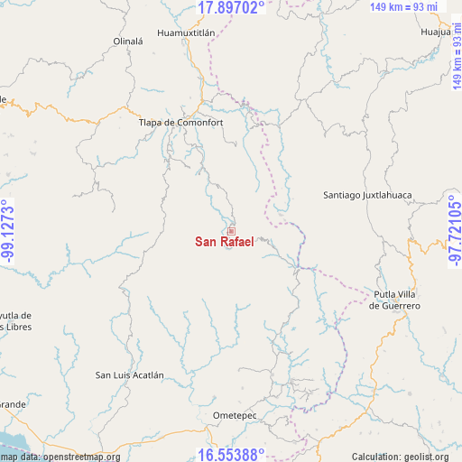
San Rafael GPS coordinates[2]
17° 13' 36.012" North, 98° 25' 27.012" West
| Map corner | latitude | longitude |
|---|---|---|
| Upper-left | 17.89702°, | -99.1273° |
| Center: | 17.22667°, | -98.42417° |
| Lower-right: | 16.55388°, | -97.72105° |
| Map W x H: | 149.3×149.3 km | = 92.8×92.8mi |
| max Lat: | 32.7° ⇑86.2% North |
| San Rafael: | 17.22667° |
| min Lat: | ⇓13.8% South 14.53588° |
| min Long | San Rafael | max Long |
| -117.105° | -98.42417° | -86.73105° |
| W 58.3%⇐ | ⇒41.7% E |
Elevation
Elevation of San Rafael is 2182 m = 7159 ft, and this is 928.3 m = 3046 ft above average elevation for this country.
| Max E: |
3497 m = 11473 ft | 18.3% |
| San Rafael | 2182 m 7159 ft | |
| Avg. | 1253.7 m = 4113 ft | |
Min E: |
-1 m = -3 ft | 81.7% |
See also: Mexico elevation on elevation.city.
Geographical zone
San Rafael is located in North Torrid zone (between Equator and Tropic of Cancer). Distance of this Northern Tropic circle is 690.5 km =429.1 mi to North.| Distance of | km | miles | from San Rafael |
|---|---|---|---|
| North Pole | 8091.6 | 5027.9 | to North |
| Arctic Circle | 5485.7 | 3408.7 | to North |
| Tropic Cancer | 690.5 | 429.1 | to North |
| Equator | 1915.4 | 1190.2 | to South |


Nearby cities:
15 places around San Rafael: (largest is in red/bold)
• Cochoapa el Grande
5.1 km =3.2 mi,  221°
221°
• Cocuilotlazala
8.2 km =5.1 mi,  357°
357°
• Francisco I. Madero
12.6 km =7.8 mi,  314°
314°
• Huexoapa (San Juan Huexoapa)
2.8 km =1.7 mi,  22°
22°
• Juanacatlán
14.6 km =9.1 mi,  320°
320°
• Lomazóyatl (Lomazoya)
14.7 km =9.1 mi,  344°
344°
• Melchor Ocampo
14.9 km =9.3 mi,  350°
350°
• Metlatónoc
4 km =2.5 mi,  152°
152°
• San Juan Puerto Montaña
11.7 km =7.3 mi,  299°
299°
• San Pablo Atzompa
6.2 km =3.9 mi,  68°
68°
• San Vicente Zoyatlán
12.4 km =7.7 mi,  30°
30°
• Santa Cruz
15.8 km =9.8 mi, 309°
• Tierra Blanca
6.8 km =4.2 mi, 315°
• Yuvinani
3.6 km =2.2 mi,  115°
115°
• Zilacayotitlán
15.3 km =9.5 mi, 299°
Sources, notices
• [Note1] Compared only with cities in Mexico existing in our database
• [Src1] Map data: © OpenStreetMap contributors (CC-BY-SA)
• [Src2] Other city data from geonames.org with taken over terms of usage.
• [Src3] Geographical zone / Annual Mean Temperature by Robert A. Rohde @ Wikipedia
