Tabi geodata
Tabi (Yucatán) is a populated place; located in Mexico in America/Merida (GMT-6) time zone. With population of 708 people, there are 12292 cities with bigger population in this country. Compared to other cities in Mexico, 69.9% of cities are located further ↓South; 98.9% of cities are located further ←West and 89.7% of cities have higher elevation than Tabi. Note1


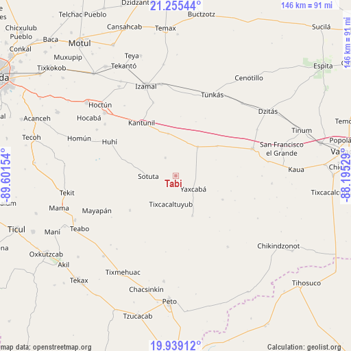
Tabi GPS coordinates[2]
20° 35' 55.32" North, 88° 53' 54.276" West
| Map corner | latitude | longitude |
|---|---|---|
| Upper-left | 21.25544°, | -89.60154° |
| Center: | 20.5987°, | -88.89841° |
| Lower-right: | 19.93912°, | -88.19529° |
| Map W x H: | 146.4×146.4 km | = 91×91mi |
| max Lat: | 32.7° ⇑30.1% North |
| Tabi: | 20.5987° |
| min Lat: | ⇓69.9% South 14.53588° |
| min Long | Tabi | max Long |
| -117.105° | -88.89841° | -86.73105° |
| W 98.9%⇐ | ⇒1.1% E |
Elevation
Elevation of Tabi is 25 m = 82 ft, and this is 1228.7 m = 4031 ft below average elevation for this country.
| Max E: |
3497 m = 11473 ft | 89.7% |
| Avg. | 1253.7 m = 4113 ft | |
| Tabi | 25 m = 82 ft | |
Min E: |
-1 m = -3 ft | 10.3% |
See also: Mexico elevation on elevation.city.
Geographical zone
Tabi is located in North Torrid zone (between Equator and Tropic of Cancer). Distance of this Northern Tropic circle is 315.6 km =196.1 mi to North.| Distance of | km | miles | from Tabi |
|---|---|---|---|
| North Pole | 7716.7 | 4794.9 | to North |
| Arctic Circle | 5110.8 | 3175.7 | to North |
| Tropic Cancer | 315.6 | 196.1 | to North |
| Equator | 2290.4 | 1423.2 | to South |


Nearby cities:
15 places around Tabi: (largest is in red/bold)
• Cantamayec
23.9 km =14.9 mi,  233°
233°
• Holca
17.8 km =11.1 mi,  349°
349°
• Huhi
30.7 km =19.1 mi,  297°
297°
• Kancabdzonot
22 km =13.7 mi,  116°
116°
• Kantunil
26.2 km =16.3 mi,  327°
327°
• Libre Unión
15.1 km =9.4 mi,  37°
37°
• Sotuta
11.4 km =7.1 mi,  268°
268°
• Tahdzibichen
18.1 km =11.2 mi,  157°
157°
• Tibolón
8.6 km =5.3 mi, 330°
• Tixcacaltuyub
11.9 km =7.4 mi,  189°
189°
• Xanabá
29 km =18 mi,  335°
335°
• Yaxcabá
9.3 km =5.8 mi,  126°
126°
• Yaxunah
24 km =14.9 mi,  105°
105°
• Yokdzonot
21.3 km =13.2 mi,  54°
54°
• Zavala
22.6 km =14 mi, 273°
Sources, notices
• [Note1] Compared only with cities in Mexico existing in our database
• [Src1] Map data: © OpenStreetMap contributors (CC-BY-SA)
• [Src2] Other city data from geonames.org with taken over terms of usage.
• [Src3] Geographical zone / Annual Mean Temperature by Robert A. Rohde @ Wikipedia
