Yaxcabá geodata
Yaxcabá (Yucatán) is a seat of a second-order administrative division; located in Mexico in America/Merida (GMT-6) time zone. With population of 3,007 people, there are 2985 cities with bigger population in this country. Compared to other cities in Mexico, 68.8% of cities are located further ↓South; 98.9% of cities are located further ←West and 89% of cities have higher elevation than Yaxcabá. Note1


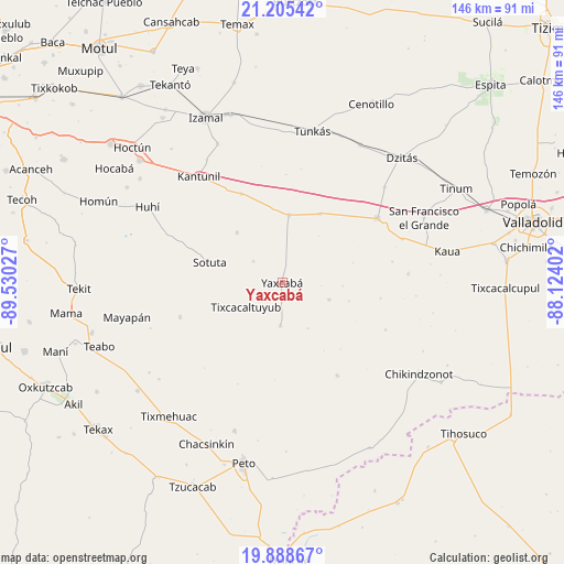
Yaxcabá GPS coordinates[2]
20° 32' 54.456" North, 88° 49' 37.704" West
| Map corner | latitude | longitude |
|---|---|---|
| Upper-left | 21.20542°, | -89.53027° |
| Center: | 20.54846°, | -88.82714° |
| Lower-right: | 19.88867°, | -88.12402° |
| Map W x H: | 146.4×146.4 km | = 91×91mi |
| max Lat: | 32.7° ⇑31.2% North |
| Yaxcabá: | 20.54846° |
| min Lat: | ⇓68.8% South 14.53588° |
| min Long | Yaxcabá | max Long |
| -117.105° | -88.82714° | -86.73105° |
| W 98.9%⇐ | ⇒1.1% E |
Elevation
Elevation of Yaxcabá is 27 m = 89 ft, and this is 1226.7 m = 4025 ft below average elevation for this country.
| Max E: |
3497 m = 11473 ft | 89% |
| Avg. | 1253.7 m = 4113 ft | |
| Yaxcabá | 27 m = 89 ft | |
Min E: |
-1 m = -3 ft | 11% |
See also: Mexico elevation on elevation.city.
Geographical zone
Yaxcabá is located in North Torrid zone (between Equator and Tropic of Cancer). Distance of this Northern Tropic circle is 321.1 km =199.5 mi to North.| Distance of | km | miles | from Yaxcabá |
|---|---|---|---|
| North Pole | 7722.3 | 4798.4 | to North |
| Arctic Circle | 5116.4 | 3179.2 | to North |
| Tropic Cancer | 321.1 | 199.5 | to North |
| Equator | 2284.8 | 1419.7 | to South |


Nearby cities:
15 places around Yaxcabá: (largest is in red/bold)
• Cantamayec
27.9 km =17.3 mi,  251°
251°
• Holca
25.4 km =15.8 mi,  335°
335°
• Kancabdzonot
12.9 km =8 mi,  109°
109°
• Libre Unión
17.7 km =11 mi,  5°
5°
• Sotuta
19.6 km =12.2 mi,  285°
285°
• Tabi
9.3 km =5.8 mi,  306°
306°
• Tahdzibichen
11 km =6.8 mi,  181°
181°
• Tibolón
17.5 km =10.9 mi,  318°
318°
• Ticimul
29.2 km =18.1 mi,  79°
79°
• Tiholop
28 km =17.4 mi,  149°
149°
• Timul
28.9 km =18 mi,  203°
203°
• Tixcacaltuyub
11.1 km =6.9 mi,  236°
236°
• Xcopteil
25.9 km =16.1 mi,  98°
98°
• Yaxunah
15.8 km =9.8 mi,  92°
92°
• Yokdzonot
20.5 km =12.7 mi,  28°
28°
Sources, notices
• [Note1] Compared only with cities in Mexico existing in our database
• [Src1] Map data: © OpenStreetMap contributors (CC-BY-SA)
• [Src2] Other city data from geonames.org with taken over terms of usage.
• [Src3] Geographical zone / Annual Mean Temperature by Robert A. Rohde @ Wikipedia
