Tibolón geodata
Tibolón (Yucatán) is a populated place; located in Mexico in America/Merida (GMT-6) time zone. With population of 1,633 people, there are 5302 cities with bigger population in this country. Compared to other cities in Mexico, 71.2% of cities are located further ↓South; 98.8% of cities are located further ←West and 91.6% of cities have higher elevation than Tibolón. Note1


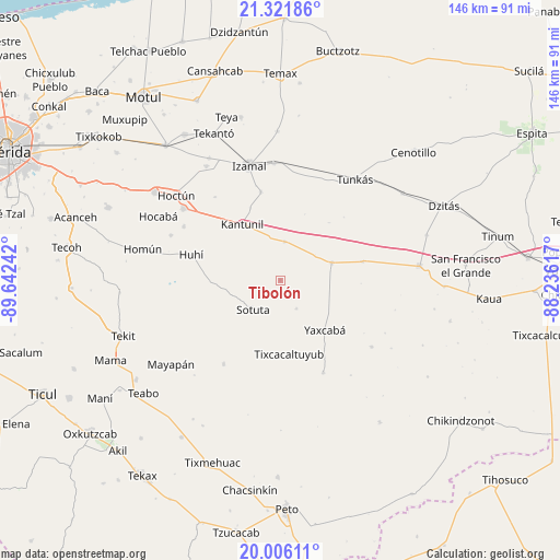
Tibolón GPS coordinates[2]
20° 39' 55.476" North, 88° 56' 21.444" West
| Map corner | latitude | longitude |
|---|---|---|
| Upper-left | 21.32186°, | -89.64242° |
| Center: | 20.66541°, | -88.93929° |
| Lower-right: | 20.00611°, | -88.23617° |
| Map W x H: | 146.3×146.3 km | = 90.9×90.9mi |
| max Lat: | 32.7° ⇑28.8% North |
| Tibolón: | 20.66541° |
| min Lat: | ⇓71.2% South 14.53588° |
| min Long | Tibolón | max Long |
| -117.105° | -88.93929° | -86.73105° |
| W 98.8%⇐ | ⇒1.2% E |
Elevation
Elevation of Tibolón is 20 m = 66 ft, and this is 1233.7 m = 4048 ft below average elevation for this country.
| Max E: |
3497 m = 11473 ft | 91.6% |
| Avg. | 1253.7 m = 4113 ft | |
| Tibolón | 20 m = 66 ft | |
Min E: |
-1 m = -3 ft | 8.4% |
See also: Mexico elevation on elevation.city.
Geographical zone
Tibolón is located in North Torrid zone (between Equator and Tropic of Cancer). Distance of this Northern Tropic circle is 308.1 km =191.4 mi to North.| Distance of | km | miles | from Tibolón |
|---|---|---|---|
| North Pole | 7709.3 | 4790.3 | to North |
| Arctic Circle | 5103.4 | 3171.1 | to North |
| Tropic Cancer | 308.1 | 191.4 | to North |
| Equator | 2297.8 | 1427.8 | to South |


Nearby cities:
15 places around Tibolón: (largest is in red/bold)
• Cantamayec
26.3 km =16.3 mi,  214°
214°
• Cuauhtémoc
25.5 km =15.8 mi,  345°
345°
• Holca
10.2 km =6.3 mi,  5°
5°
• Huhi
24 km =14.9 mi,  286°
286°
• Kantunil
17.7 km =11 mi,  325°
325°
• Libre Unión
14.2 km =8.8 mi,  71°
71°
• Sotuta
10.5 km =6.5 mi,  223°
223°
• Sudzal
23.6 km =14.7 mi, 347°
• Tabi
8.6 km =5.3 mi,  150°
150°
• Tahdzibichen
26.6 km =16.5 mi, 154°
• Tixcacaltuyub
19.3 km =12 mi,  172°
172°
• Xanabá
20.5 km =12.7 mi,  337°
337°
• Yaxcabá
17.5 km =10.9 mi,  138°
138°
• Yokdzonot
22.1 km =13.7 mi,  77°
77°
• Zavala
19.3 km =12 mi,  251°
251°
Sources, notices
• [Note1] Compared only with cities in Mexico existing in our database
• [Src1] Map data: © OpenStreetMap contributors (CC-BY-SA)
• [Src2] Other city data from geonames.org with taken over terms of usage.
• [Src3] Geographical zone / Annual Mean Temperature by Robert A. Rohde @ Wikipedia
