San Cristóbal geodata
San Cristóbal (Veracruz) is a populated place; located in Mexico in America/Mexico_City (GMT-6) time zone. With population of 712 people, there are 12235 cities with bigger population in this country. Compared to other cities in Mexico, 80.4% of cities are located further ↑North; 85.4% of cities are located further ←West and 95.1% of cities have higher elevation than San Cristóbal. Note1


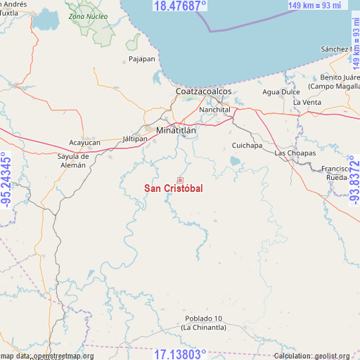
San Cristóbal GPS coordinates[2]
17° 48' 31.356" North, 94° 32' 25.152" West
| Map corner | latitude | longitude |
|---|---|---|
| Upper-left | 18.47687°, | -95.24345° |
| Center: | 17.80871°, | -94.54032° |
| Lower-right: | 17.13803°, | -93.8372° |
| Map W x H: | 148.9×148.9 km | = 92.5×92.5mi |
| max Lat: | 32.7° ⇑80.4% North |
| San Cristóbal: | 17.80871° |
| min Lat: | ⇓19.6% South 14.53588° |
| min Long | San Cristóbal | max Long |
| -117.105° | -94.54032° | -86.73105° |
| W 85.4%⇐ | ⇒14.6% E |
Elevation
Elevation of San Cristóbal is 13 m = 43 ft, and this is 1240.7 m = 4071 ft below average elevation for this country.
| Max E: |
3497 m = 11473 ft | 95.1% |
| Avg. | 1253.7 m = 4113 ft | |
| San Cristóbal | 13 m = 43 ft | |
Min E: |
-1 m = -3 ft | 4.9% |
See also: Mexico elevation on elevation.city.
Geographical zone
San Cristóbal is located in North Torrid zone (between Equator and Tropic of Cancer). Distance of this Northern Tropic circle is 625.8 km =388.9 mi to North.| Distance of | km | miles | from San Cristóbal |
|---|---|---|---|
| North Pole | 8026.9 | 4987.7 | to North |
| Arctic Circle | 5421 | 3368.5 | to North |
| Tropic Cancer | 625.8 | 388.9 | to North |
| Equator | 1980.1 | 1230.4 | to South |


Nearby cities:
15 places around San Cristóbal: (largest is in red/bold)
• Coacotla
19.5 km =12.1 mi,  316°
316°
• El Jagüey
17.7 km =11 mi,  351°
351°
• El Macayal
21.3 km =13.2 mi,  214°
214°
• Emilio Carranza (Salinas)
1.8 km =1.1 mi,  257°
257°
• Hidalgotitlán
12.1 km =7.5 mi,  249°
249°
• La Concepción
20.9 km =13 mi,  75°
75°
• La Victoria
12.1 km =7.5 mi,  299°
299°
• Las Lomas
16 km =9.9 mi, 352°
• Las Lomas de Tacamichapan
18.9 km =11.7 mi,  289°
289°
• Las Ánimas
12.2 km =7.6 mi, 346°
• Limonta
12.6 km =7.8 mi, 319°
• Minatitlán
21.4 km =13.3 mi,  355°
355°
• Monte Alto
13.5 km =8.4 mi, 317°
• San Pedro Mártir
20.3 km =12.6 mi,  338°
338°
• Zaragoza
19.8 km =12.3 mi,  326°
326°
Sources, notices
• [Note1] Compared only with cities in Mexico existing in our database
• [Src1] Map data: © OpenStreetMap contributors (CC-BY-SA)
• [Src2] Other city data from geonames.org with taken over terms of usage.
• [Src3] Geographical zone / Annual Mean Temperature by Robert A. Rohde @ Wikipedia
