Hidalgotitlán geodata
Hidalgotitlán (Veracruz) is a seat of a second-order administrative division; located in Mexico in America/Mexico_City (GMT-6) time zone. With population of 3,980 people, there are 2289 cities with bigger population in this country. Compared to other cities in Mexico, 80.8% of cities are located further ↑North; 85.2% of cities are located further ←West and 90% of cities have higher elevation than Hidalgotitlán. Note1


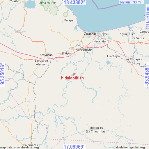
Hidalgotitlán GPS coordinates[2]
17° 46' 13.836" North, 94° 38' 49.308" West
| Map corner | latitude | longitude |
|---|---|---|
| Upper-left | 18.43882°, | -95.35016° |
| Center: | 17.77051°, | -94.64703° |
| Lower-right: | 17.09969°, | -93.94391° |
| Map W x H: | 148.9×148.9 km | = 92.5×92.5mi |
| max Lat: | 32.7° ⇑80.8% North |
| Hidalgotitlán: | 17.77051° |
| min Lat: | ⇓19.2% South 14.53588° |
| min Long | Hidalgotitlán | max Long |
| -117.105° | -94.64703° | -86.73105° |
| W 85.2%⇐ | ⇒14.8% E |
Elevation
Elevation of Hidalgotitlán is 24 m = 79 ft, and this is 1229.7 m = 4034 ft below average elevation for this country.
| Max E: |
3497 m = 11473 ft | 90% |
| Avg. | 1253.7 m = 4113 ft | |
| Hidalgotitlán | 24 m = 79 ft | |
Min E: |
-1 m = -3 ft | 10% |
See also: Mexico elevation on elevation.city.
Geographical zone
Hidalgotitlán is located in North Torrid zone (between Equator and Tropic of Cancer). Distance of this Northern Tropic circle is 630 km =391.5 mi to North.| Distance of | km | miles | from Hidalgotitlán |
|---|---|---|---|
| North Pole | 8031.2 | 4990.4 | to North |
| Arctic Circle | 5425.3 | 3371.1 | to North |
| Tropic Cancer | 630 | 391.5 | to North |
| Equator | 1975.9 | 1227.8 | to South |


Nearby cities:
15 places around Hidalgotitlán: (largest is in red/bold)
• Coacotla
18.6 km =11.6 mi,  353°
353°
• El Macayal
13.3 km =8.3 mi,  183°
183°
• Emilio Carranza (Salinas)
10.3 km =6.4 mi,  67°
67°
• La Victoria
10.3 km =6.4 mi,  4°
4°
• Las Lomas
22.1 km =13.7 mi,  24°
24°
• Las Lomas de Tacamichapan
12.5 km =7.8 mi,  328°
328°
• Las Ánimas
18.1 km =11.2 mi,  27°
27°
• Licenciado Gabriel Ramos Millán
22.1 km =13.7 mi,  209°
209°
• Limonta
14.1 km =8.8 mi,  12°
12°
• Monte Alto
14.4 km =8.9 mi, 8°
• San Carlos
11.8 km =7.3 mi, 212°
• San Cristóbal
12.1 km =7.5 mi, 69°
• San Lorenzo Tenochtitlán
12.1 km =7.5 mi,  261°
261°
• Venustiano Carranza (Peña Blanca)
18.3 km =11.4 mi,  218°
218°
• Zaragoza
20.8 km =12.9 mi, 1°
Sources, notices
• [Note1] Compared only with cities in Mexico existing in our database
• [Src1] Map data: © OpenStreetMap contributors (CC-BY-SA)
• [Src2] Other city data from geonames.org with taken over terms of usage.
• [Src3] Geographical zone / Annual Mean Temperature by Robert A. Rohde @ Wikipedia
