Xochimilco geodata
Xochimilco (Veracruz) is a populated place; located in Mexico in America/Mexico_City (GMT-6) time zone. With population of 1,334 people, there are 6517 cities with bigger population in this country. Compared to other cities in Mexico, 74.1% of cities are located further ↓South; 62.8% of cities are located further ←West and 72.7% of cities have higher elevation than Xochimilco. Note1


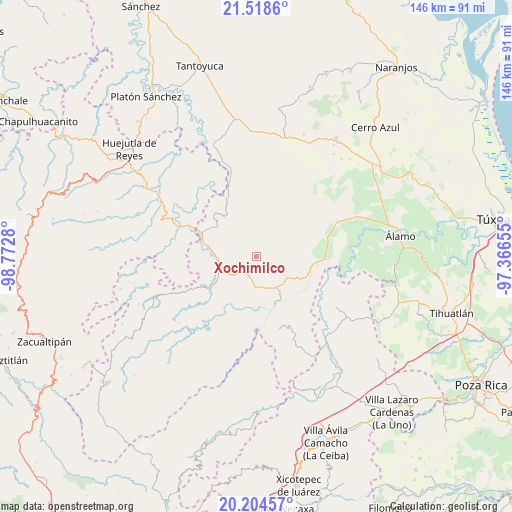
Xochimilco GPS coordinates[2]
20° 51' 46.872" North, 98° 4' 10.812" West
| Map corner | latitude | longitude |
|---|---|---|
| Upper-left | 21.5186°, | -98.7728° |
| Center: | 20.86302°, | -98.06967° |
| Lower-right: | 20.20457°, | -97.36655° |
| Map W x H: | 146.1×146.1 km | = 90.8×90.8mi |
| max Lat: | 32.7° ⇑25.9% North |
| Xochimilco: | 20.86302° |
| min Lat: | ⇓74.1% South 14.53588° |
| min Long | Xochimilco | max Long |
| -117.105° | -98.06967° | -86.73105° |
| W 62.8%⇐ | ⇒37.2% E |
Elevation
Elevation of Xochimilco is 304 m = 997 ft, and this is 949.7 m = 3116 ft below average elevation for this country.
| Max E: |
3497 m = 11473 ft | 72.7% |
| Avg. | 1253.7 m = 4113 ft | |
| Xochimilco | 304 m = 997 ft | |
Min E: |
-1 m = -3 ft | 27.3% |
See also: Mexico elevation on elevation.city.
Geographical zone
Xochimilco is located in North Torrid zone (between Equator and Tropic of Cancer). Distance of this Northern Tropic circle is 286.2 km =177.8 mi to North.| Distance of | km | miles | from Xochimilco |
|---|---|---|---|
| North Pole | 7687.3 | 4776.7 | to North |
| Arctic Circle | 5081.4 | 3157.4 | to North |
| Tropic Cancer | 286.2 | 177.8 | to North |
| Equator | 2319.8 | 1441.5 | to South |


Nearby cities:
15 places around Xochimilco: (largest is in red/bold)
• Ayolia
9 km =5.6 mi,  113°
113°
• Cacahuatengo
9.2 km =5.7 mi,  160°
160°
• Colatlán
5.9 km =3.7 mi,  208°
208°
• El Limón
3.5 km =2.2 mi,  143°
143°
• Huexotitla
10.5 km =6.5 mi,  190°
190°
• Hueycuatitla
11 km =6.8 mi,  272°
272°
• Ixcacuatitla
6.9 km =4.3 mi,  43°
43°
• La Reforma
9.5 km =5.9 mi,  236°
236°
• Llano de Enmedio
10.6 km =6.6 mi,  146°
146°
• Lomas del Dorado
11.2 km =7 mi,  122°
122°
• Palma Real
9.3 km =5.8 mi,  226°
226°
• Pemuxtitla
10.1 km =6.3 mi,  300°
300°
• Piedra Grande
9.6 km =6 mi, 163°
• Pilpuerta
10.5 km =6.5 mi, 209°
• Reyixtla
2 km =1.2 mi,  47°
47°
Sources, notices
• [Note1] Compared only with cities in Mexico existing in our database
• [Src1] Map data: © OpenStreetMap contributors (CC-BY-SA)
• [Src2] Other city data from geonames.org with taken over terms of usage.
• [Src3] Geographical zone / Annual Mean Temperature by Robert A. Rohde @ Wikipedia
