Cadenqui geodata
Cadenqui (State of Mexico) is a populated place; located in Mexico in America/Mexico_City (GMT-6) time zone. With population of 709 people, there are 12279 cities with bigger population in this country. Compared to other cities in Mexico, 52.7% of cities are located further ↓South; 58.5% of cities are located further →East and 98.3% of cities have lower elevation than Cadenqui. Note1


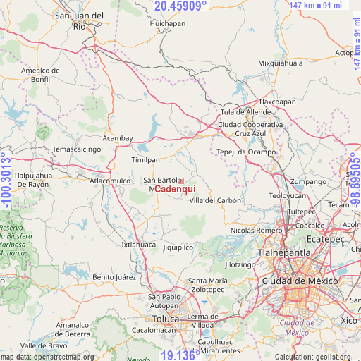
Cadenqui GPS coordinates[2]
19° 47' 56.112" North, 99° 35' 53.412" West
| Map corner | latitude | longitude |
|---|---|---|
| Upper-left | 20.45909°, | -100.3013° |
| Center: | 19.79892°, | -99.59817° |
| Lower-right: | 19.136°, | -98.89505° |
| Map W x H: | 147.1×147.1 km | = 91.4×91.4mi |
| max Lat: | 32.7° ⇑47.3% North |
| Cadenqui: | 19.79892° |
| min Lat: | ⇓52.7% South 14.53588° |
| min Long | Cadenqui | max Long |
| -117.105° | -99.59817° | -86.73105° |
| W 41.5%⇐ | ⇒58.5% E |
Elevation
Elevation of Cadenqui is 2773 m = 9098 ft, and this is 1519.3 m = 4985 ft above average elevation for this country.
| Max E: |
3497 m = 11473 ft | 1.7% |
| Cadenqui | 2773 m 9098 ft | |
| Avg. | 1253.7 m = 4113 ft | |
Min E: |
-1 m = -3 ft | 98.3% |
See also: Mexico elevation on elevation.city.
Geographical zone
Cadenqui is located in North Torrid zone (between Equator and Tropic of Cancer). Distance of this Northern Tropic circle is 404.5 km =251.3 mi to North.| Distance of | km | miles | from Cadenqui |
|---|---|---|---|
| North Pole | 7805.6 | 4850.2 | to North |
| Arctic Circle | 5199.7 | 3230.9 | to North |
| Tropic Cancer | 404.5 | 251.3 | to North |
| Equator | 2201.4 | 1367.9 | to South |


Nearby cities:
15 places around Cadenqui: (largest is in red/bold)
• Barrio Tercero
6.8 km =4.2 mi,  256°
256°
• Chapa de Mota
7.7 km =4.8 mi,  77°
77°
• Dongu
5 km =3.1 mi,  13°
13°
• La Cruz (San Simón la Cruz)
7.9 km =4.9 mi,  172°
172°
• La Esperanza
6.3 km =3.9 mi,  51°
51°
• La Ladera
3.8 km =2.4 mi,  66°
66°
• San Bartolo Morelos
7.5 km =4.7 mi, 259°
• San Felipe Coamango
6.7 km =4.2 mi,  352°
352°
• San Francisco de las Tablas
8.1 km =5 mi,  116°
116°
• San Gregorio Macapexco Barrio Segundo
4.8 km =3 mi,  223°
223°
• San Juan Tuxtepec
7.6 km =4.7 mi,  331°
331°
• San Sebastián Buenos Aires
8 km =5 mi,  184°
184°
• Santa Clara de Juárez
8.9 km =5.5 mi,  185°
185°
• Santa María
7.9 km =4.9 mi,  35°
35°
• Tenjay
4.9 km =3 mi, 78°
Sources, notices
• [Note1] Compared only with cities in Mexico existing in our database
• [Src1] Map data: © OpenStreetMap contributors (CC-BY-SA)
• [Src2] Other city data from geonames.org with taken over terms of usage.
• [Src3] Geographical zone / Annual Mean Temperature by Robert A. Rohde @ Wikipedia
