La Ladera geodata
La Ladera (State of Mexico) is a populated place; located in Mexico in America/Mexico_City (GMT-6) time zone. With population of 557 people, there are 15314 cities with bigger population in this country. Compared to other cities in Mexico, 53.1% of cities are located further ↓South; 57.8% of cities are located further →East and 97.2% of cities have lower elevation than La Ladera. Note1


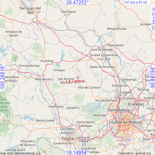
La Ladera GPS coordinates[2]
19° 48' 44.676" North, 99° 33' 54.216" West
| Map corner | latitude | longitude |
|---|---|---|
| Upper-left | 20.47253°, | -100.26819° |
| Center: | 19.81241°, | -99.56506° |
| Lower-right: | 19.14954°, | -98.86194° |
| Map W x H: | 147.1×147.1 km | = 91.4×91.4mi |
| max Lat: | 32.7° ⇑46.9% North |
| La Ladera: | 19.81241° |
| min Lat: | ⇓53.1% South 14.53588° |
| min Long | La Ladera | max Long |
| -117.105° | -99.56506° | -86.73105° |
| W 42.2%⇐ | ⇒57.8% E |
Elevation
Elevation of La Ladera is 2689 m = 8822 ft, and this is 1435.3 m = 4709 ft above average elevation for this country.
| Max E: |
3497 m = 11473 ft | 2.8% |
| La Ladera | 2689 m 8822 ft | |
| Avg. | 1253.7 m = 4113 ft | |
Min E: |
-1 m = -3 ft | 97.2% |
See also: Mexico elevation on elevation.city.
Geographical zone
La Ladera is located in North Torrid zone (between Equator and Tropic of Cancer). Distance of this Northern Tropic circle is 403 km =250.4 mi to North.| Distance of | km | miles | from La Ladera |
|---|---|---|---|
| North Pole | 7804.1 | 4849.2 | to North |
| Arctic Circle | 5198.2 | 3230 | to North |
| Tropic Cancer | 403 | 250.4 | to North |
| Equator | 2202.9 | 1368.8 | to South |


Nearby cities:
15 places around La Ladera: (largest is in red/bold)
• Cadenqui
3.8 km =2.4 mi,  246°
246°
• Chapa de Mota
4.1 km =2.5 mi,  87°
87°
• Dongu
4.1 km =2.5 mi,  326°
326°
• Doxhicho
9.8 km =6.1 mi,  4°
4°
• La Capilla
10.2 km =6.3 mi,  151°
151°
• La Cruz (San Simón la Cruz)
9.6 km =6 mi,  194°
194°
• La Esperanza
2.9 km =1.8 mi,  32°
32°
• Monte de Peña
9.2 km =5.7 mi,  168°
168°
• San Felipe Coamango
6.8 km =4.2 mi,  319°
319°
• San Francisco de las Tablas
6.4 km =4 mi,  144°
144°
• San Gregorio Macapexco Barrio Segundo
8.4 km =5.2 mi,  233°
233°
• San Juan Tuxtepec
8.8 km =5.5 mi,  305°
305°
• San Sebastián Buenos Aires
10.3 km =6.4 mi,  203°
203°
• Santa María
5.1 km =3.2 mi,  12°
12°
• Tenjay
1.4 km =0.9 mi,  111°
111°
Sources, notices
• [Note1] Compared only with cities in Mexico existing in our database
• [Src1] Map data: © OpenStreetMap contributors (CC-BY-SA)
• [Src2] Other city data from geonames.org with taken over terms of usage.
• [Src3] Geographical zone / Annual Mean Temperature by Robert A. Rohde @ Wikipedia
