Santa María geodata
Santa María (State of Mexico) is a populated place; located in Mexico in America/Mexico_City (GMT-6) time zone. With population of 1,111 people, there are 7820 cities with bigger population in this country. Compared to other cities in Mexico, 54.2% of cities are located further ↓South; 57.7% of cities are located further →East and 95.8% of cities have lower elevation than Santa María. Note1


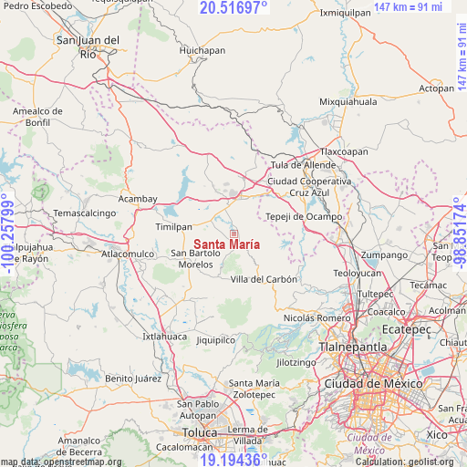
Santa María GPS coordinates[2]
19° 51' 25.344" North, 99° 33' 17.496" West
| Map corner | latitude | longitude |
|---|---|---|
| Upper-left | 20.51697°, | -100.25799° |
| Center: | 19.85704°, | -99.55486° |
| Lower-right: | 19.19436°, | -98.85174° |
| Map W x H: | 147.1×147.1 km | = 91.4×91.4mi |
| max Lat: | 32.7° ⇑45.8% North |
| Santa María: | 19.85704° |
| min Lat: | ⇓54.2% South 14.53588° |
| min Long | Santa María | max Long |
| -117.105° | -99.55486° | -86.73105° |
| W 42.3%⇐ | ⇒57.7% E |
Elevation
Elevation of Santa María is 2619 m = 8593 ft, and this is 1365.3 m = 4479 ft above average elevation for this country.
| Max E: |
3497 m = 11473 ft | 4.2% |
| Santa María | 2619 m 8593 ft | |
| Avg. | 1253.7 m = 4113 ft | |
Min E: |
-1 m = -3 ft | 95.8% |
See also: Mexico elevation on elevation.city.
Geographical zone
Santa María is located in North Torrid zone (between Equator and Tropic of Cancer). Distance of this Northern Tropic circle is 398 km =247.3 mi to North.| Distance of | km | miles | from Santa María |
|---|---|---|---|
| North Pole | 7799.2 | 4846.2 | to North |
| Arctic Circle | 5193.3 | 3227 | to North |
| Tropic Cancer | 398 | 247.3 | to North |
| Equator | 2207.9 | 1371.9 | to South |


Nearby cities:
15 places around Santa María: (largest is in red/bold)
• Cadenqui
7.9 km =4.9 mi,  215°
215°
• Chapa de Mota
5.6 km =3.5 mi,  147°
147°
• Coscomate del Progreso
9.4 km =5.8 mi,  23°
23°
• Denjhi
7.4 km =4.6 mi, 15°
• Dongu
3.7 km =2.3 mi,  244°
244°
• Doxhicho
4.8 km =3 mi,  356°
356°
• Ejido de Coscomate del Progreso
8.6 km =5.3 mi,  5°
5°
• El Durazno de Cuauhtémoc
8.2 km =5.1 mi,  319°
319°
• El Magueyal
9.7 km =6 mi,  347°
347°
• La Esperanza
2.6 km =1.6 mi,  169°
169°
• La Ladera
5.1 km =3.2 mi,  192°
192°
• San Felipe Coamango
5.4 km =3.4 mi,  272°
272°
• San Gabriel
10.2 km =6.3 mi,  290°
290°
• San Juan Tuxtepec
8.2 km =5.1 mi, 271°
• Tenjay
5.5 km =3.4 mi,  177°
177°
Sources, notices
• [Note1] Compared only with cities in Mexico existing in our database
• [Src1] Map data: © OpenStreetMap contributors (CC-BY-SA)
• [Src2] Other city data from geonames.org with taken over terms of usage.
• [Src3] Geographical zone / Annual Mean Temperature by Robert A. Rohde @ Wikipedia
