Pilotos geodata
Pilotos (Aguascalientes) is a populated place; located in Mexico in America/Mexico_City (GMT-6) time zone. With population of 1,331 people, there are 6524 cities with bigger population in this country. Compared to other cities in Mexico, 84.4% of cities are located further ↓South; 80.7% of cities are located further →East and 75.3% of cities have lower elevation than Pilotos. Note1


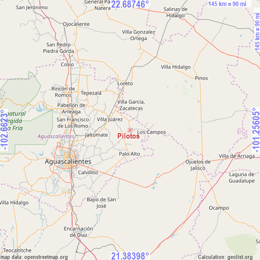
Pilotos GPS coordinates[2]
22° 2' 13.992" North, 101° 57' 33.012" West
| Map corner | latitude | longitude |
|---|---|---|
| Upper-left | 22.68746°, | -102.6623° |
| Center: | 22.03722°, | -101.95917° |
| Lower-right: | 21.38398°, | -101.25605° |
| Map W x H: | 144.9×144.9 km | = 90×90mi |
| max Lat: | 32.7° ⇑15.6% North |
| Pilotos: | 22.03722° |
| min Lat: | ⇓84.4% South 14.53588° |
| min Long | Pilotos | max Long |
| -117.105° | -101.95917° | -86.73105° |
| W 19.3%⇐ | ⇒80.7% E |
Elevation
Elevation of Pilotos is 2036 m = 6680 ft, and this is 782.3 m = 2567 ft above average elevation for this country.
| Max E: |
3497 m = 11473 ft | 24.7% |
| Pilotos | 2036 m 6680 ft | |
| Avg. | 1253.7 m = 4113 ft | |
Min E: |
-1 m = -3 ft | 75.3% |
See also: Mexico elevation on elevation.city.
Geographical zone
Pilotos is located in North Torrid zone (between Equator and Tropic of Cancer). Distance of this Northern Tropic circle is 155.6 km =96.7 mi to North.| Distance of | km | miles | from Pilotos |
|---|---|---|---|
| North Pole | 7556.8 | 4695.6 | to North |
| Arctic Circle | 4950.9 | 3076.3 | to North |
| Tropic Cancer | 155.6 | 96.7 | to North |
| Equator | 2450.3 | 1522.5 | to South |


Nearby cities:
15 places around Pilotos: (largest is in red/bold)
• Agua Gorda
8.6 km =5.3 mi,  26°
26°
• Agua Gordita
10.7 km =6.6 mi,  354°
354°
• El Copetillo
12.6 km =7.8 mi,  339°
339°
• El Novillo
4.7 km =2.9 mi,  246°
246°
• Francisco Sarabia (La Reforma)
9.8 km =6.1 mi,  219°
219°
• Francisco Villa
5.7 km =3.5 mi, 349°
• Granadas
12.1 km =7.5 mi,  54°
54°
• Jilotepec
12.3 km =7.6 mi,  269°
269°
• La Luz
5.6 km =3.5 mi, 222°
• Las Negritas
9.9 km =6.2 mi,  122°
122°
• Licenciado Jesús Terán (El Muerto)
12.6 km =7.8 mi,  238°
238°
• Los Campos
11.9 km =7.4 mi,  95°
95°
• Ojo de Agua de Crucitas
8.1 km =5 mi,  174°
174°
• Tierritas Blancas
10.2 km =6.3 mi, 25°
• Villa Juárez
13 km =8.1 mi,  299°
299°
Sources, notices
• [Note1] Compared only with cities in Mexico existing in our database
• [Src1] Map data: © OpenStreetMap contributors (CC-BY-SA)
• [Src2] Other city data from geonames.org with taken over terms of usage.
• [Src3] Geographical zone / Annual Mean Temperature by Robert A. Rohde @ Wikipedia
