Estación Ventura geodata
Estación Ventura (San Luis Potosí) is a populated place; located in Mexico in America/Mexico_City (GMT-6) time zone. With population of 585 people, there are 14661 cities with bigger population in this country. Compared to other cities in Mexico, 86.2% of cities are located further ↓South; 71.6% of cities are located further →East and 65% of cities have lower elevation than Estación Ventura. Note1


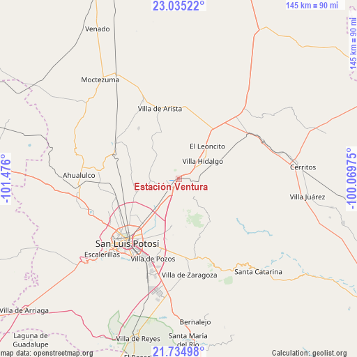
Estación Ventura GPS coordinates[2]
22° 23' 11.832" North, 100° 46' 22.332" West
| Map corner | latitude | longitude |
|---|---|---|
| Upper-left | 23.03522°, | -101.476° |
| Center: | 22.38662°, | -100.77287° |
| Lower-right: | 21.73498°, | -100.06975° |
| Map W x H: | 144.6×144.6 km | = 89.9×89.9mi |
| max Lat: | 32.7° ⇑13.8% North |
| Estación Ventura: | 22.38662° |
| min Lat: | ⇓86.2% South 14.53588° |
| min Long | Estación Ventu | max Long |
| -117.105° | -100.77287° | -86.73105° |
| W 28.4%⇐ | ⇒71.6% E |
Elevation
Elevation of Estación Ventura is 1830 m = 6004 ft, and this is 576.3 m = 1891 ft above average elevation for this country.
| Max E: |
3497 m = 11473 ft | 35% |
| Estación Ventura | 1830 m 6004 ft | |
| Avg. | 1253.7 m = 4113 ft | |
Min E: |
-1 m = -3 ft | 65% |
See also: Mexico elevation on elevation.city.
Geographical zone
Estación Ventura is located in North Torrid zone (between Equator and Tropic of Cancer). Distance of this Northern Tropic circle is 116.8 km =72.6 mi to North.| Distance of | km | miles | from Estación Ventura |
|---|---|---|---|
| North Pole | 7517.9 | 4671.4 | to North |
| Arctic Circle | 4912 | 3052.2 | to North |
| Tropic Cancer | 116.8 | 72.6 | to North |
| Equator | 2489.2 | 1546.7 | to South |


Nearby cities:
15 places around Estación Ventura: (largest is in red/bold)
• Armadillo de los Infante
19.8 km =12.3 mi,  142°
142°
• Cerro de San Pedro
19 km =11.8 mi,  188°
188°
• Corcovado
8.2 km =5.1 mi,  83°
83°
• El Peñasco
19.5 km =12.1 mi,  249°
249°
• Enrique Estrada
20.2 km =12.6 mi,  216°
216°
• La Concordia
19.6 km =12.2 mi,  100°
100°
• La Melada
22.5 km =14 mi,  296°
296°
• La Redonda
14 km =8.7 mi,  64°
64°
• Mantequilla
12 km =7.5 mi,  292°
292°
• Palma de la Cruz
20.3 km =12.6 mi,  209°
209°
• Pedrera del Tanquito
1.7 km =1.1 mi,  73°
73°
• Peotillos
20.4 km =12.7 mi,  54°
54°
• San Lorenzo
23.1 km =14.4 mi,  33°
33°
• Veinte de Noviembre
14.6 km =9.1 mi, 77°
• Villa Hidalgo
12 km =7.5 mi, 53°
Sources, notices
• [Note1] Compared only with cities in Mexico existing in our database
• [Src1] Map data: © OpenStreetMap contributors (CC-BY-SA)
• [Src2] Other city data from geonames.org with taken over terms of usage.
• [Src3] Geographical zone / Annual Mean Temperature by Robert A. Rohde @ Wikipedia
