Corcovado geodata
Corcovado (San Luis Potosí) is a populated place; located in Mexico in America/Mexico_City (GMT-6) time zone. With population of 1,490 people, there are 5789 cities with bigger population in this country. Compared to other cities in Mexico, 86.2% of cities are located further ↓South; 71% of cities are located further →East and 58% of cities have lower elevation than Corcovado. Note1


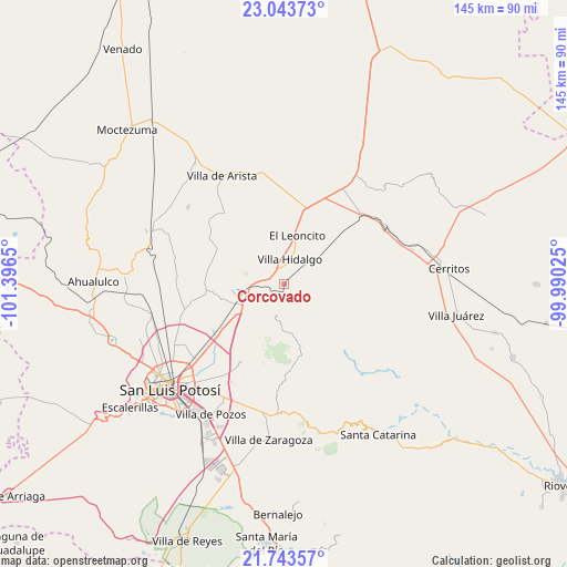
Corcovado GPS coordinates[2]
22° 23' 42.612" North, 100° 41' 36.132" West
| Map corner | latitude | longitude |
|---|---|---|
| Upper-left | 23.04373°, | -101.3965° |
| Center: | 22.39517°, | -100.69337° |
| Lower-right: | 21.74357°, | -99.99025° |
| Map W x H: | 144.6×144.6 km | = 89.9×89.9mi |
| max Lat: | 32.7° ⇑13.8% North |
| Corcovado: | 22.39517° |
| min Lat: | ⇓86.2% South 14.53588° |
| min Long | Corcovado | max Long |
| -117.105° | -100.69337° | -86.73105° |
| W 29%⇐ | ⇒71% E |
Elevation
Elevation of Corcovado is 1691 m = 5548 ft, and this is 437.3 m = 1435 ft above average elevation for this country.
| Max E: |
3497 m = 11473 ft | 42% |
| Corcovado | 1691 m 5548 ft | |
| Avg. | 1253.7 m = 4113 ft | |
Min E: |
-1 m = -3 ft | 58% |
See also: Mexico elevation on elevation.city.
Geographical zone
Corcovado is located in North Torrid zone (between Equator and Tropic of Cancer). Distance of this Northern Tropic circle is 115.8 km =72 mi to North.| Distance of | km | miles | from Corcovado |
|---|---|---|---|
| North Pole | 7517 | 4670.8 | to North |
| Arctic Circle | 4911.1 | 3051.6 | to North |
| Tropic Cancer | 115.8 | 72 | to North |
| Equator | 2490.1 | 1547.3 | to South |


Nearby cities:
15 places around Corcovado: (largest is in red/bold)
• Armadillo de los Infante
17.1 km =10.6 mi,  166°
166°
• Cerro de San Pedro
22.5 km =14 mi,  208°
208°
• El Charquito
25.9 km =16.1 mi,  0°
0°
• Enrique Estrada
26.5 km =16.5 mi,  229°
229°
• Estación Ventura
8.2 km =5.1 mi,  263°
263°
• La Concordia
11.9 km =7.4 mi,  111°
111°
• La Redonda
6.8 km =4.2 mi,  40°
40°
• Mantequilla
19.6 km =12.2 mi,  280°
280°
• Palma de la Cruz
26.1 km =16.2 mi,  224°
224°
• Pedrera del Tanquito
6.6 km =4.1 mi,  266°
266°
• Peotillos
13.8 km =8.6 mi, 37°
• San Lorenzo
18.8 km =11.7 mi,  14°
14°
• San Nicolás Tolentino
21.8 km =13.5 mi,  138°
138°
• Veinte de Noviembre
6.4 km =4 mi,  70°
70°
• Villa Hidalgo
6.3 km =3.9 mi, 14°
Sources, notices
• [Note1] Compared only with cities in Mexico existing in our database
• [Src1] Map data: © OpenStreetMap contributors (CC-BY-SA)
• [Src2] Other city data from geonames.org with taken over terms of usage.
• [Src3] Geographical zone / Annual Mean Temperature by Robert A. Rohde @ Wikipedia
