Peotillos geodata
Peotillos (San Luis Potosí) is a populated place; located in Mexico in America/Mexico_City (GMT-6) time zone. With population of 1,198 people, there are 7249 cities with bigger population in this country. Compared to other cities in Mexico, 86.7% of cities are located further ↓South; 70.4% of cities are located further →East and 51.6% of cities have lower elevation than Peotillos. Note1


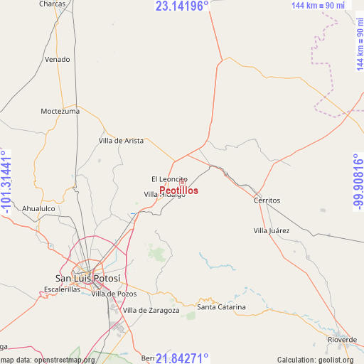
Peotillos GPS coordinates[2]
22° 29' 37.896" North, 100° 36' 40.608" West
| Map corner | latitude | longitude |
|---|---|---|
| Upper-left | 23.14196°, | -101.31441° |
| Center: | 22.49386°, | -100.61128° |
| Lower-right: | 21.84271°, | -99.90816° |
| Map W x H: | 144.5×144.5 km | = 89.8×89.8mi |
| max Lat: | 32.7° ⇑13.3% North |
| Peotillos: | 22.49386° |
| min Lat: | ⇓86.7% South 14.53588° |
| min Long | Peotillos | max Long |
| -117.105° | -100.61128° | -86.73105° |
| W 29.6%⇐ | ⇒70.4% E |
Elevation
Elevation of Peotillos is 1511 m = 4957 ft, and this is 257.3 m = 844 ft above average elevation for this country.
| Max E: |
3497 m = 11473 ft | 48.4% |
| Peotillos | 1511 m 4957 ft | |
| Avg. | 1253.7 m = 4113 ft | |
Min E: |
-1 m = -3 ft | 51.6% |
See also: Mexico elevation on elevation.city.
Geographical zone
Peotillos is located in North Torrid zone (between Equator and Tropic of Cancer). Distance of this Northern Tropic circle is 104.8 km =65.1 mi to North.| Distance of | km | miles | from Peotillos |
|---|---|---|---|
| North Pole | 7506 | 4664 | to North |
| Arctic Circle | 4900.1 | 3044.8 | to North |
| Tropic Cancer | 104.8 | 65.1 | to North |
| Equator | 2501.1 | 1554.1 | to South |


Nearby cities:
15 places around Peotillos: (largest is in red/bold)
• Charco Blanco
18.1 km =11.2 mi,  31°
31°
• Corcovado
13.8 km =8.6 mi,  217°
217°
• El Charquito
17.1 km =10.6 mi,  330°
330°
• Estación Ventura
20.4 km =12.7 mi,  234°
234°
• Guadalcázar
25.8 km =16 mi,  57°
57°
• Joya de Luna
20.5 km =12.7 mi,  108°
108°
• La Concordia
15.6 km =9.7 mi,  170°
170°
• La Redonda
7 km =4.3 mi,  214°
214°
• Núñez
24.2 km =15 mi, 26°
• Pedrera del Tanquito
18.8 km =11.7 mi, 232°
• Peyote
17.9 km =11.1 mi,  1°
1°
• Salitrillo
21 km =13 mi, 325°
• San Lorenzo
8.2 km =5.1 mi, 332°
• Veinte de Noviembre
9.1 km =5.7 mi,  195°
195°
• Villa Hidalgo
8.4 km =5.2 mi, 234°
Sources, notices
• [Note1] Compared only with cities in Mexico existing in our database
• [Src1] Map data: © OpenStreetMap contributors (CC-BY-SA)
• [Src2] Other city data from geonames.org with taken over terms of usage.
• [Src3] Geographical zone / Annual Mean Temperature by Robert A. Rohde @ Wikipedia
