Veinte de Noviembre geodata
Veinte de Noviembre (San Luis Potosí) is a populated place; located in Mexico in America/Mexico_City (GMT-6) time zone. With population of 743 people, there are 11779 cities with bigger population in this country. Compared to other cities in Mexico, 86.4% of cities are located further ↓South; 70.6% of cities are located further →East and 55.7% of cities have lower elevation than Veinte de Noviembre. Note1


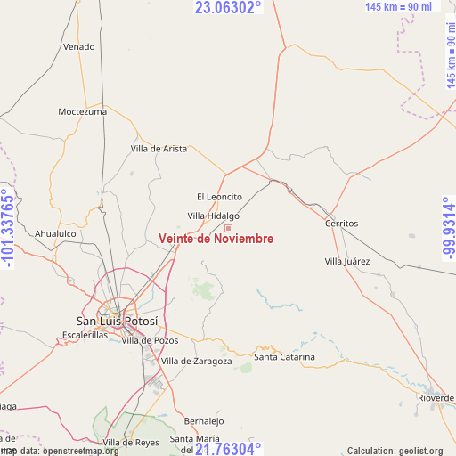
Veinte de Noviembre GPS coordinates[2]
22° 24' 52.38" North, 100° 38' 4.272" West
| Map corner | latitude | longitude |
|---|---|---|
| Upper-left | 23.06302°, | -101.33765° |
| Center: | 22.41455°, | -100.63452° |
| Lower-right: | 21.76304°, | -99.9314° |
| Map W x H: | 144.5×144.5 km | = 89.8×89.8mi |
| max Lat: | 32.7° ⇑13.6% North |
| Veinte de Noviembre: | 22.41455° |
| min Lat: | ⇓86.4% South 14.53588° |
| min Long | Veinte de Novie | max Long |
| -117.105° | -100.63452° | -86.73105° |
| W 29.4%⇐ | ⇒70.6% E |
Elevation
Elevation of Veinte de Noviembre is 1607 m = 5272 ft, and this is 353.3 m = 1159 ft above average elevation for this country.
| Max E: |
3497 m = 11473 ft | 44.3% |
| Veinte de Noviembre | 1607 m 5272 ft | |
| Avg. | 1253.7 m = 4113 ft | |
Min E: |
-1 m = -3 ft | 55.7% |
See also: Mexico elevation on elevation.city.
Geographical zone
Veinte de Noviembre is located in North Torrid zone (between Equator and Tropic of Cancer). Distance of this Northern Tropic circle is 113.7 km =70.6 mi to North.| Distance of | km | miles | from Veinte de Noviembre |
|---|---|---|---|
| North Pole | 7514.8 | 4669.5 | to North |
| Arctic Circle | 4908.9 | 3050.2 | to North |
| Tropic Cancer | 113.7 | 70.6 | to North |
| Equator | 2492.3 | 1548.6 | to South |


Nearby cities:
15 places around Veinte de Noviembre: (largest is in red/bold)
• Armadillo de los Infante
19 km =11.8 mi,  186°
186°
• Charco Blanco
27 km =16.8 mi,  25°
25°
• Corcovado
6.4 km =4 mi,  250°
250°
• El Charquito
24.5 km =15.2 mi,  345°
345°
• Estación Ventura
14.6 km =9.1 mi,  257°
257°
• Joya de Luna
21.9 km =13.6 mi,  84°
84°
• La Concordia
8.2 km =5.1 mi,  142°
142°
• La Redonda
3.4 km =2.1 mi,  331°
331°
• Mantequilla
25.3 km =15.7 mi,  273°
273°
• Pedrera del Tanquito
12.9 km =8 mi, 258°
• Peotillos
9.1 km =5.7 mi,  15°
15°
• Peyote
26.9 km =16.7 mi,  6°
6°
• San Lorenzo
16.1 km =10 mi,  355°
355°
• San Nicolás Tolentino
20.3 km =12.6 mi,  155°
155°
• Villa Hidalgo
6 km =3.7 mi,  311°
311°
Sources, notices
• [Note1] Compared only with cities in Mexico existing in our database
• [Src1] Map data: © OpenStreetMap contributors (CC-BY-SA)
• [Src2] Other city data from geonames.org with taken over terms of usage.
• [Src3] Geographical zone / Annual Mean Temperature by Robert A. Rohde @ Wikipedia
