Sáenz geodata
Sáenz (Chihuahua) is a populated place; located in Mexico in America/Chihuahua (GMT-6) time zone. With population of 532 people, there are 15923 cities with bigger population in this country. Compared to other cities in Mexico, 97.8% of cities are located further ↓South; 94.7% of cities are located further →East and 76.3% of cities have lower elevation than Sáenz. Note1


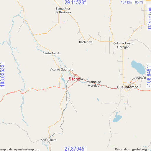
Sáenz GPS coordinates[2]
28° 29' 57.012" North, 107° 21' 7.992" West
| Map corner | latitude | longitude |
|---|---|---|
| Upper-left | 29.11528°, | -108.05535° |
| Center: | 28.49917°, | -107.35222° |
| Lower-right: | 27.87945°, | -106.6491° |
| Map W x H: | 137.4×137.4 km | = 85.4×85.4mi |
| max Lat: | 32.7° ⇑2.2% North |
| Sáenz: | 28.49917° |
| min Lat: | ⇓97.8% South 14.53588° |
| min Long | Sáenz | max Long |
| -117.105° | -107.35222° | -86.73105° |
| W 5.3%⇐ | ⇒94.7% E |
Elevation
Elevation of Sáenz is 2054 m = 6739 ft, and this is 800.3 m = 2626 ft above average elevation for this country.
| Max E: |
3497 m = 11473 ft | 23.7% |
| Sáenz | 2054 m 6739 ft | |
| Avg. | 1253.7 m = 4113 ft | |
Min E: |
-1 m = -3 ft | 76.3% |
See also: Mexico elevation on elevation.city.
Geographical zone
Sáenz is located in North temperate zone (between Tropic of Cancer and the Arctic Circle). Distance of this Northern Tropic circle is 562.9 km =349.8 mi to South.| Distance of | km | miles | from Sáenz |
|---|---|---|---|
| North Pole | 6838.3 | 4249.1 | to North |
| Arctic Circle | 4232.4 | 2629.9 | to North |
| Tropic Cancer | 562.9 | 349.8 | to South |
| Equator | 3168.8 | 1969 | to South |


Nearby cities:
15 places around Sáenz: (largest is in red/bold)
• Adolfo López Mateos
6.3 km =3.9 mi,  125°
125°
• Bachíniva
31.3 km =19.4 mi,  17°
17°
• Basúchil
5.6 km =3.5 mi,  300°
300°
• Borjas
7.6 km =4.7 mi, 299°
• Campo Número Dos
40.3 km =25 mi,  98°
98°
• Cuauhtémoc
48.9 km =30.4 mi, 101°
• Guerrero
14 km =8.7 mi,  293°
293°
• La Junta
3.1 km =1.9 mi, 133°
• Pachera
24.3 km =15.1 mi,  190°
190°
• Paramo
17.8 km =11.1 mi,  114°
114°
• Pedernales
25.6 km =15.9 mi, 112°
• Ranchos de Santiago
23.3 km =14.5 mi, 134°
• Santo Tomás
29.7 km =18.5 mi,  313°
313°
• Tacuba
20.3 km =12.6 mi,  215°
215°
• Álamos de Cerro Prieto
42.2 km =26.2 mi,  144°
144°
Sources, notices
• [Note1] Compared only with cities in Mexico existing in our database
• [Src1] Map data: © OpenStreetMap contributors (CC-BY-SA)
• [Src2] Other city data from geonames.org with taken over terms of usage.
• [Src3] Geographical zone / Annual Mean Temperature by Robert A. Rohde @ Wikipedia
