Basúchil geodata
Basúchil (Chihuahua) is a populated place; located in Mexico in America/Chihuahua (GMT-6) time zone. With population of 1,451 people, there are 5948 cities with bigger population in this country. Compared to other cities in Mexico, 97.8% of cities are located further ↓South; 94.9% of cities are located further →East and 75.3% of cities have lower elevation than Basúchil. Note1


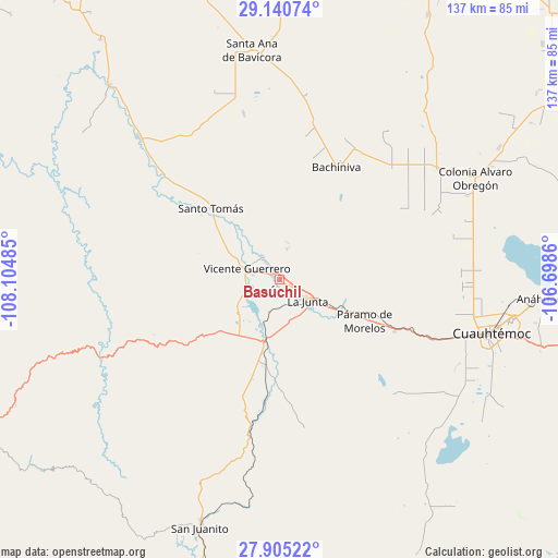
Basúchil GPS coordinates[2]
28° 31' 29.244" North, 107° 24' 6.192" West
| Map corner | latitude | longitude |
|---|---|---|
| Upper-left | 29.14074°, | -108.10485° |
| Center: | 28.52479°, | -107.40172° |
| Lower-right: | 27.90522°, | -106.6986° |
| Map W x H: | 137.4×137.4 km | = 85.4×85.4mi |
| max Lat: | 32.7° ⇑2.2% North |
| Basúchil: | 28.52479° |
| min Lat: | ⇓97.8% South 14.53588° |
| min Long | Basúchil | max Long |
| -117.105° | -107.40172° | -86.73105° |
| W 5.1%⇐ | ⇒94.9% E |
Elevation
Elevation of Basúchil is 2036 m = 6680 ft, and this is 782.3 m = 2567 ft above average elevation for this country.
| Max E: |
3497 m = 11473 ft | 24.7% |
| Basúchil | 2036 m 6680 ft | |
| Avg. | 1253.7 m = 4113 ft | |
Min E: |
-1 m = -3 ft | 75.3% |
See also: Mexico elevation on elevation.city.
Geographical zone
Basúchil is located in North temperate zone (between Tropic of Cancer and the Arctic Circle). Distance of this Northern Tropic circle is 565.7 km =351.5 mi to South.| Distance of | km | miles | from Basúchil |
|---|---|---|---|
| North Pole | 6835.4 | 4247.3 | to North |
| Arctic Circle | 4229.5 | 2628.1 | to North |
| Tropic Cancer | 565.7 | 351.5 | to South |
| Equator | 3171.7 | 1970.8 | to South |


Nearby cities:
15 places around Basúchil: (largest is in red/bold)
• Adolfo López Mateos
11.9 km =7.4 mi,  123°
123°
• Bachíniva
30.6 km =19 mi,  27°
27°
• Borjas
2 km =1.2 mi,  295°
295°
• Campo Número Dos
45.5 km =28.3 mi,  100°
100°
• Guerrero
8.4 km =5.2 mi,  288°
288°
• La Junta
8.6 km =5.3 mi,  125°
125°
• Pachera
26.7 km =16.6 mi,  179°
179°
• Paramo
23.4 km =14.5 mi, 116°
• Pedernales
31.1 km =19.3 mi,  113°
113°
• Ranchos de Santiago
28.8 km =17.9 mi, 131°
• Santo Tomás
24.2 km =15 mi,  316°
316°
• Sáenz
5.6 km =3.5 mi, 120°
• Tacuba
20.5 km =12.7 mi,  199°
199°
• Tomochic
47.4 km =29.5 mi,  246°
246°
• Álamos de Cerro Prieto
47.4 km =29.5 mi,  142°
142°
Sources, notices
• [Note1] Compared only with cities in Mexico existing in our database
• [Src1] Map data: © OpenStreetMap contributors (CC-BY-SA)
• [Src2] Other city data from geonames.org with taken over terms of usage.
• [Src3] Geographical zone / Annual Mean Temperature by Robert A. Rohde @ Wikipedia
