La Paz geodata
La Paz (Jalisco) is a populated place; located in Mexico in America/Mexico_City (GMT-6) time zone. With population of 1,342 people, there are 6480 cities with bigger population in this country. Compared to other cities in Mexico, 83.1% of cities are located further ↓South; 79.5% of cities are located further →East and 79.5% of cities have lower elevation than La Paz. Note1


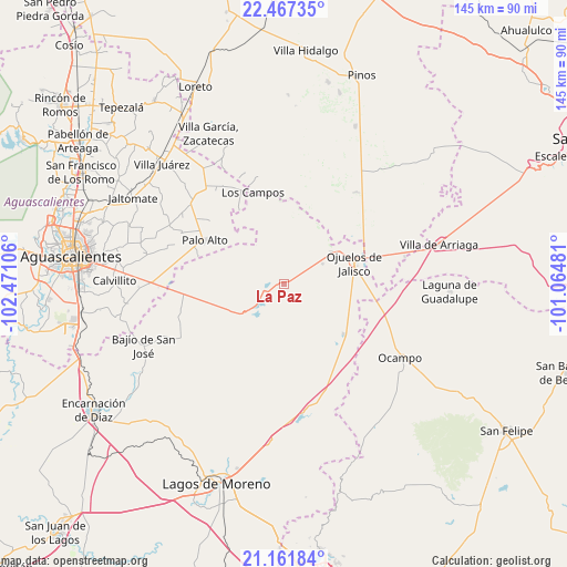
La Paz GPS coordinates[2]
21° 48' 57.888" North, 101° 46' 4.548" West
| Map corner | latitude | longitude |
|---|---|---|
| Upper-left | 22.46735°, | -102.47106° |
| Center: | 21.81608°, | -101.76793° |
| Lower-right: | 21.16184°, | -101.06481° |
| Map W x H: | 145.2×145.2 km | = 90.2×90.2mi |
| max Lat: | 32.7° ⇑16.9% North |
| La Paz: | 21.81608° |
| min Lat: | ⇓83.1% South 14.53588° |
| min Long | La Paz | max Long |
| -117.105° | -101.76793° | -86.73105° |
| W 20.5%⇐ | ⇒79.5% E |
Elevation
Elevation of La Paz is 2127 m = 6978 ft, and this is 873.3 m = 2865 ft above average elevation for this country.
| Max E: |
3497 m = 11473 ft | 20.5% |
| La Paz | 2127 m 6978 ft | |
| Avg. | 1253.7 m = 4113 ft | |
Min E: |
-1 m = -3 ft | 79.5% |
See also: Mexico elevation on elevation.city.
Geographical zone
La Paz is located in North Torrid zone (between Equator and Tropic of Cancer). Distance of this Northern Tropic circle is 180.2 km =112 mi to North.| Distance of | km | miles | from La Paz |
|---|---|---|---|
| North Pole | 7581.3 | 4710.8 | to North |
| Arctic Circle | 4975.5 | 3091.6 | to North |
| Tropic Cancer | 180.2 | 112 | to North |
| Equator | 2425.7 | 1507.3 | to South |


Nearby cities:
15 places around La Paz: (largest is in red/bold)
• Chinampas
5.4 km =3.4 mi,  295°
295°
• Francisco Primo de Verdad (Ciénega de Mata)
10 km =6.2 mi,  217°
217°
• Guadalupe Victoria
20.1 km =12.5 mi,  129°
129°
• Hierba de Matancillas
11.2 km =7 mi,  60°
60°
• La Presa
6.6 km =4.1 mi,  227°
227°
• La Presita
21.6 km =13.4 mi,  41°
41°
• La Punta
17.9 km =11.1 mi,  268°
268°
• La Troje
16.9 km =10.5 mi,  236°
236°
• Los Azulitos
20.6 km =12.8 mi,  279°
279°
• Matancillas (San Isidro Matancillas)
14.7 km =9.1 mi, 55°
• Ninguno [Granja]
8.6 km =5.3 mi,  14°
14°
• Ojo de Agua de la Palma
21.3 km =13.2 mi, 11°
• Ojuelos de Jalisco
18.9 km =11.7 mi,  72°
72°
• Tacubaya
20.4 km =12.7 mi,  258°
258°
• Vaquerías
12.9 km =8 mi,  114°
114°
Sources, notices
• [Note1] Compared only with cities in Mexico existing in our database
• [Src1] Map data: © OpenStreetMap contributors (CC-BY-SA)
• [Src2] Other city data from geonames.org with taken over terms of usage.
• [Src3] Geographical zone / Annual Mean Temperature by Robert A. Rohde @ Wikipedia
