Los Campos geodata
Los Campos (Jalisco) is a populated place; located in Mexico in America/Mexico_City (GMT-6) time zone. With population of 824 people, there are 10606 cities with bigger population in this country. Compared to other cities in Mexico, 84.4% of cities are located further ↓South; 79.9% of cities are located further →East and 78.9% of cities have lower elevation than Los Campos. Note1


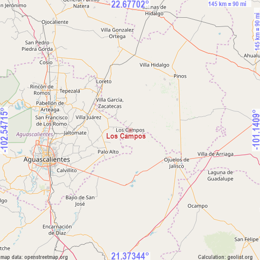
Los Campos GPS coordinates[2]
22° 1' 36.228" North, 101° 50' 38.472" West
| Map corner | latitude | longitude |
|---|---|---|
| Upper-left | 22.67702°, | -102.54715° |
| Center: | 22.02673°, | -101.84402° |
| Lower-right: | 21.37344°, | -101.1409° |
| Map W x H: | 144.9×144.9 km | = 90×90mi |
| max Lat: | 32.7° ⇑15.6% North |
| Los Campos: | 22.02673° |
| min Lat: | ⇓84.4% South 14.53588° |
| min Long | Los Campos | max Long |
| -117.105° | -101.84402° | -86.73105° |
| W 20.1%⇐ | ⇒79.9% E |
Elevation
Elevation of Los Campos is 2111 m = 6926 ft, and this is 857.3 m = 2813 ft above average elevation for this country.
| Max E: |
3497 m = 11473 ft | 21.1% |
| Los Campos | 2111 m 6926 ft | |
| Avg. | 1253.7 m = 4113 ft | |
Min E: |
-1 m = -3 ft | 78.9% |
See also: Mexico elevation on elevation.city.
Geographical zone
Los Campos is located in North Torrid zone (between Equator and Tropic of Cancer). Distance of this Northern Tropic circle is 156.8 km =97.4 mi to North.| Distance of | km | miles | from Los Campos |
|---|---|---|---|
| North Pole | 7557.9 | 4696.3 | to North |
| Arctic Circle | 4952 | 3077 | to North |
| Tropic Cancer | 156.8 | 97.4 | to North |
| Equator | 2449.1 | 1521.8 | to South |


Nearby cities:
15 places around Los Campos: (largest is in red/bold)
• Agua Gorda
12 km =7.5 mi,  317°
317°
• El Novillo
16.2 km =10.1 mi,  267°
267°
• Emilio Carranza
17.3 km =10.7 mi,  2°
2°
• Francisco Villa
14.6 km =9.1 mi,  297°
297°
• Granadas
8.5 km =5.3 mi,  346°
346°
• La Laborcilla
15.2 km =9.4 mi,  53°
53°
• La Luz
15.9 km =9.9 mi,  259°
259°
• La Montesa
4.4 km =2.7 mi,  17°
17°
• La Puerta de Jalisco
16.4 km =10.2 mi, 21°
• Las Negritas
5.5 km =3.4 mi,  220°
220°
• Ojo de Agua de Crucitas
13.1 km =8.1 mi,  238°
238°
• Ojo de Agua de la Palma
12.3 km =7.6 mi,  102°
102°
• Palo Alto
17.3 km =10.7 mi,  225°
225°
• Pilotos
11.9 km =7.4 mi,  275°
275°
• Tierritas Blancas
12.8 km =8 mi, 323°
Sources, notices
• [Note1] Compared only with cities in Mexico existing in our database
• [Src1] Map data: © OpenStreetMap contributors (CC-BY-SA)
• [Src2] Other city data from geonames.org with taken over terms of usage.
• [Src3] Geographical zone / Annual Mean Temperature by Robert A. Rohde @ Wikipedia
