La Luz geodata
La Luz (Aguascalientes) is a populated place; located in Mexico in America/Mexico_City (GMT-6) time zone. With population of 870 people, there are 10041 cities with bigger population in this country. Compared to other cities in Mexico, 84.2% of cities are located further ↓South; 80.9% of cities are located further →East and 74.8% of cities have lower elevation than La Luz. Note1


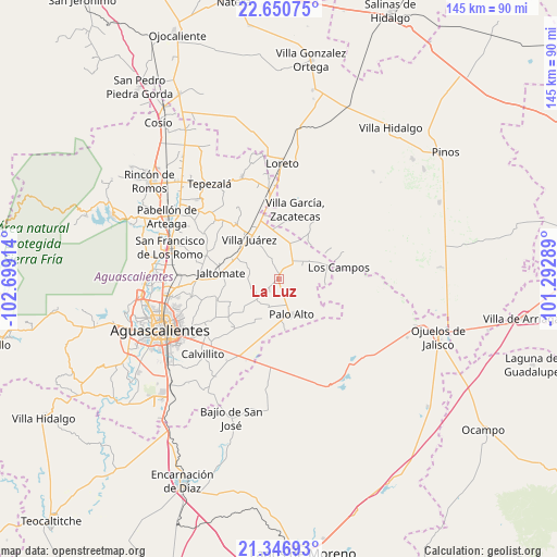
La Luz GPS coordinates[2]
22° 0' 1.224" North, 101° 59' 45.636" West
| Map corner | latitude | longitude |
|---|---|---|
| Upper-left | 22.65075°, | -102.69914° |
| Center: | 22.00034°, | -101.99601° |
| Lower-right: | 21.34693°, | -101.29289° |
| Map W x H: | 145×145 km | = 90.1×90.1mi |
| max Lat: | 32.7° ⇑15.8% North |
| La Luz: | 22.00034° |
| min Lat: | ⇓84.2% South 14.53588° |
| min Long | La Luz | max Long |
| -117.105° | -101.99601° | -86.73105° |
| W 19.1%⇐ | ⇒80.9% E |
Elevation
Elevation of La Luz is 2026 m = 6647 ft, and this is 772.3 m = 2534 ft above average elevation for this country.
| Max E: |
3497 m = 11473 ft | 25.2% |
| La Luz | 2026 m 6647 ft | |
| Avg. | 1253.7 m = 4113 ft | |
Min E: |
-1 m = -3 ft | 74.8% |
See also: Mexico elevation on elevation.city.
Geographical zone
La Luz is located in North Torrid zone (between Equator and Tropic of Cancer). Distance of this Northern Tropic circle is 159.7 km =99.2 mi to North.| Distance of | km | miles | from La Luz |
|---|---|---|---|
| North Pole | 7560.9 | 4698.1 | to North |
| Arctic Circle | 4955 | 3078.9 | to North |
| Tropic Cancer | 159.7 | 99.2 | to North |
| Equator | 2446.2 | 1520 | to South |


Nearby cities:
15 places around La Luz: (largest is in red/bold)
• El Novillo
2.3 km =1.4 mi,  345°
345°
• El Tule
13.5 km =8.4 mi,  313°
313°
• Francisco Sarabia (La Reforma)
4.2 km =2.6 mi,  214°
214°
• Francisco Villa
10.1 km =6.3 mi,  15°
15°
• Jilotepec
9.4 km =5.8 mi,  295°
295°
• La Dichosa
12.7 km =7.9 mi,  290°
290°
• Las Negritas
12.2 km =7.6 mi,  95°
95°
• Licenciado Jesús Terán (El Muerto)
7.4 km =4.6 mi,  250°
250°
• Los Conos
11.4 km =7.1 mi,  179°
179°
• Ojo de Agua de Crucitas
6.1 km =3.8 mi,  131°
131°
• Palo Alto
9.7 km =6 mi,  160°
160°
• Pilotos
5.6 km =3.5 mi,  42°
42°
• Santa María Gallardo
13.4 km =8.3 mi, 293°
• Santa Rosa (El Huizache)
7.7 km =4.8 mi,  200°
200°
• Villa Juárez
12.9 km =8 mi,  324°
324°
Sources, notices
• [Note1] Compared only with cities in Mexico existing in our database
• [Src1] Map data: © OpenStreetMap contributors (CC-BY-SA)
• [Src2] Other city data from geonames.org with taken over terms of usage.
• [Src3] Geographical zone / Annual Mean Temperature by Robert A. Rohde @ Wikipedia
