La Montesa geodata
La Montesa (Zacatecas) is a populated place; located in Mexico in America/Mexico_City (GMT-6) time zone. With population of 555 people, there are 15371 cities with bigger population in this country. Compared to other cities in Mexico, 84.5% of cities are located further ↓South; 79.9% of cities are located further →East and 81.6% of cities have lower elevation than La Montesa. Note1


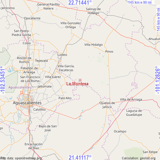
La Montesa GPS coordinates[2]
22° 3' 51.444" North, 101° 49' 52.968" West
| Map corner | latitude | longitude |
|---|---|---|
| Upper-left | 22.71441°, | -102.53451° |
| Center: | 22.06429°, | -101.83138° |
| Lower-right: | 21.41117°, | -101.12826° |
| Map W x H: | 144.9×144.9 km | = 90×90mi |
| max Lat: | 32.7° ⇑15.5% North |
| La Montesa: | 22.06429° |
| min Lat: | ⇓84.5% South 14.53588° |
| min Long | La Montesa | max Long |
| -117.105° | -101.83138° | -86.73105° |
| W 20.1%⇐ | ⇒79.9% E |
Elevation
Elevation of La Montesa is 2180 m = 7152 ft, and this is 926.3 m = 3039 ft above average elevation for this country.
| Max E: |
3497 m = 11473 ft | 18.4% |
| La Montesa | 2180 m 7152 ft | |
| Avg. | 1253.7 m = 4113 ft | |
Min E: |
-1 m = -3 ft | 81.6% |
See also: Mexico elevation on elevation.city.
Geographical zone
La Montesa is located in North Torrid zone (between Equator and Tropic of Cancer). Distance of this Northern Tropic circle is 152.6 km =94.8 mi to North.| Distance of | km | miles | from La Montesa |
|---|---|---|---|
| North Pole | 7553.7 | 4693.7 | to North |
| Arctic Circle | 4947.9 | 3074.5 | to North |
| Tropic Cancer | 152.6 | 94.8 | to North |
| Equator | 2453.3 | 1524.4 | to South |


Nearby cities:
15 places around La Montesa: (largest is in red/bold)
• Agua Gorda
10.4 km =6.5 mi,  296°
296°
• Agua Gordita
16.1 km =10 mi, 298°
• El Nigromante
15.9 km =9.9 mi,  51°
51°
• Emilio Carranza
13.1 km =8.1 mi,  358°
358°
• Francisco Villa
14.4 km =8.9 mi,  280°
280°
• Granadas
5.2 km =3.2 mi,  320°
320°
• La Laborcilla
11.9 km =7.4 mi,  66°
66°
• La Puerta de Jalisco
12 km =7.5 mi,  22°
22°
• Las Negritas
9.7 km =6 mi,  210°
210°
• Los Campos
4.4 km =2.7 mi,  197°
197°
• Ojo de Agua de Crucitas
16.7 km =10.4 mi,  228°
228°
• Ojo de Agua de la Palma
12.6 km =7.8 mi,  122°
122°
• Pilotos
13.5 km =8.4 mi,  257°
257°
• Tierritas Blancas
10.8 km =6.7 mi, 304°
• Villa García
16.8 km =10.4 mi,  310°
310°
Sources, notices
• [Note1] Compared only with cities in Mexico existing in our database
• [Src1] Map data: © OpenStreetMap contributors (CC-BY-SA)
• [Src2] Other city data from geonames.org with taken over terms of usage.
• [Src3] Geographical zone / Annual Mean Temperature by Robert A. Rohde @ Wikipedia
