Melchor Ocampo geodata
Melchor Ocampo (Zacatecas) is a populated place; located in Mexico in America/Mexico_City (GMT-6) time zone. With population of 569 people, there are 15027 cities with bigger population in this country. Compared to other cities in Mexico, 91.6% of cities are located further ↓South; 78.5% of cities are located further →East and 75.1% of cities have lower elevation than Melchor Ocampo. Note1


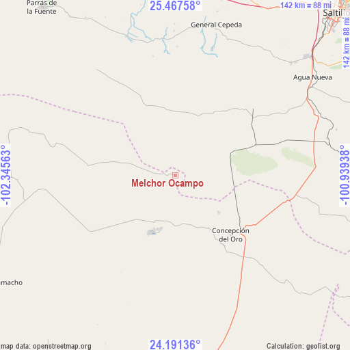
Melchor Ocampo GPS coordinates[2]
24° 49' 51.996" North, 101° 38' 33" West
| Map corner | latitude | longitude |
|---|---|---|
| Upper-left | 25.46758°, | -102.34563° |
| Center: | 24.83111°, | -101.6425° |
| Lower-right: | 24.19136°, | -100.93938° |
| Map W x H: | 141.9×141.9 km | = 88.2×88.2mi |
| max Lat: | 32.7° ⇑8.4% North |
| Melchor Ocampo: | 24.83111° |
| min Lat: | ⇓91.6% South 14.53588° |
| min Long | Melchor Ocampo | max Long |
| -117.105° | -101.6425° | -86.73105° |
| W 21.5%⇐ | ⇒78.5% E |
Elevation
Elevation of Melchor Ocampo is 2033 m = 6670 ft, and this is 779.3 m = 2557 ft above average elevation for this country.
| Max E: |
3497 m = 11473 ft | 24.9% |
| Melchor Ocampo | 2033 m 6670 ft | |
| Avg. | 1253.7 m = 4113 ft | |
Min E: |
-1 m = -3 ft | 75.1% |
See also: Mexico elevation on elevation.city.
Geographical zone
Melchor Ocampo is located in North temperate zone (between Tropic of Cancer and the Arctic Circle). Distance of this Northern Tropic circle is 155 km =96.3 mi to South.| Distance of | km | miles | from Melchor Ocampo |
|---|---|---|---|
| North Pole | 7246.1 | 4502.5 | to North |
| Arctic Circle | 4640.2 | 2883.3 | to North |
| Tropic Cancer | 155 | 96.3 | to South |
| Equator | 2761 | 1715.6 | to South |


Nearby cities:
15 places around Melchor Ocampo: (largest is in red/bold)
• Agua Nueva
68.6 km =42.6 mi,  54°
54°
• Apizolaya
64 km =39.8 mi,  268°
268°
• Caopas
53.9 km =33.5 mi,  264°
264°
• Cedros
21.5 km =13.4 mi,  218°
218°
• Colonia Fovissste
36.5 km =22.7 mi,  131°
131°
• Concepción del Oro
33.1 km =20.6 mi,  136°
136°
• Derramadero
62.6 km =38.9 mi,  35°
35°
• Estación Camacho
85.6 km =53.2 mi,  239°
239°
• General Cepeda
63 km =39.1 mi,  15°
15°
• La Curva
35 km =21.7 mi, 132°
• Mazapil
23.2 km =14.4 mi,  157°
157°
• San Juan de la Vaquería
63.3 km =39.3 mi, 42°
• San Tiburcio
77.8 km =48.3 mi,  168°
168°
• Tanque Nuevo
84.5 km =52.5 mi, 126°
• Terminal de Providencia
23.6 km =14.7 mi, 130°
Sources, notices
• [Note1] Compared only with cities in Mexico existing in our database
• [Src1] Map data: © OpenStreetMap contributors (CC-BY-SA)
• [Src2] Other city data from geonames.org with taken over terms of usage.
• [Src3] Geographical zone / Annual Mean Temperature by Robert A. Rohde @ Wikipedia
