Jauja geodata
Jauja (Durango) is a populated place; located in Mexico in America/Monterrey (GMT-6) time zone. With population of 1,101 people, there are 7901 cities with bigger population in this country. Compared to other cities in Mexico, 95% of cities are located further ↓South; 87.6% of cities are located further →East and 58.1% of cities have higher elevation than Jauja. Note1


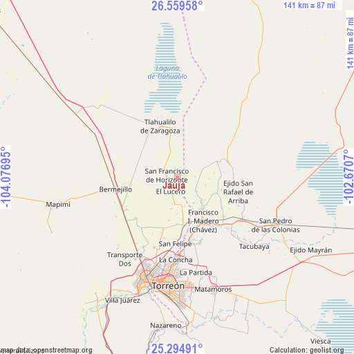
Jauja GPS coordinates[2]
25° 55' 44.184" North, 103° 22' 25.752" West
| Map corner | latitude | longitude |
|---|---|---|
| Upper-left | 26.55958°, | -104.07695° |
| Center: | 25.92894°, | -103.37382° |
| Lower-right: | 25.29491°, | -102.6707° |
| Map W x H: | 140.6×140.6 km | = 87.4×87.4mi |
| max Lat: | 32.7° ⇑5% North |
| Jauja: | 25.92894° |
| min Lat: | ⇓95% South 14.53588° |
| min Long | Jauja | max Long |
| -117.105° | -103.37382° | -86.73105° |
| W 12.4%⇐ | ⇒87.6% E |
Elevation
Elevation of Jauja is 1100 m = 3609 ft, and this is 153.7 m = 504 ft below average elevation for this country.
| Max E: |
3497 m = 11473 ft | 58.1% |
| Avg. | 1253.7 m = 4113 ft | |
| Jauja | 1100 m = 3609 ft | |
Min E: |
-1 m = -3 ft | 41.9% |
See also: Mexico elevation on elevation.city.
Geographical zone
Jauja is located in North temperate zone (between Tropic of Cancer and the Arctic Circle). Distance of this Northern Tropic circle is 277.1 km =172.2 mi to South.| Distance of | km | miles | from Jauja |
|---|---|---|---|
| North Pole | 7124 | 4426.6 | to North |
| Arctic Circle | 4518.1 | 2807.4 | to North |
| Tropic Cancer | 277.1 | 172.2 | to South |
| Equator | 2883 | 1791.4 | to South |


Nearby cities:
15 places around Jauja: (largest is in red/bold)
• Arturo Martínez Adame
10.9 km =6.8 mi,  184°
184°
• Banco Nacional
6.6 km =4.1 mi,  164°
164°
• Coruña
9.3 km =5.8 mi,  125°
125°
• Covadonga
12.6 km =7.8 mi,  92°
92°
• El Barro
10.7 km =6.6 mi,  191°
191°
• El Lucero
6.3 km =3.9 mi,  206°
206°
• Florencia
11.9 km =7.4 mi,  147°
147°
• Huitrón
8.3 km =5.2 mi, 162°
• Jiménez
11.1 km =6.9 mi,  171°
171°
• La Pinta
11.3 km =7 mi,  104°
104°
• Las Mercedes
12.5 km =7.8 mi,  142°
142°
• San Alberto
11.7 km =7.3 mi, 165°
• San Francisco de Horizonte (Horizonte)
4.4 km =2.7 mi,  281°
281°
• San Julio
4.8 km =3 mi, 279°
• Valle de Eureka
12.6 km =7.8 mi, 190°
Sources, notices
• [Note1] Compared only with cities in Mexico existing in our database
• [Src1] Map data: © OpenStreetMap contributors (CC-BY-SA)
• [Src2] Other city data from geonames.org with taken over terms of usage.
• [Src3] Geographical zone / Annual Mean Temperature by Robert A. Rohde @ Wikipedia
