Canutillo geodata
Canutillo (Durango) is a populated place; located in Mexico in America/Monterrey (GMT-6) time zone. With population of 614 people, there are 14035 cities with bigger population in this country. Compared to other cities in Mexico, 95.7% of cities are located further ↓South; 92.9% of cities are located further →East and 58% of cities have lower elevation than Canutillo. Note1


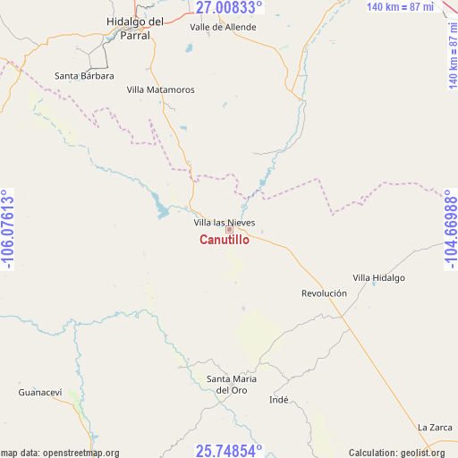
Canutillo GPS coordinates[2]
26° 22' 48.54" North, 105° 22' 22.8" West
| Map corner | latitude | longitude |
|---|---|---|
| Upper-left | 27.00833°, | -106.07613° |
| Center: | 26.38015°, | -105.373° |
| Lower-right: | 25.74854°, | -104.66988° |
| Map W x H: | 140.1×140.1 km | = 87.1×87.1mi |
| max Lat: | 32.7° ⇑4.3% North |
| Canutillo: | 26.38015° |
| min Lat: | ⇓95.7% South 14.53588° |
| min Long | Canutillo | max Long |
| -117.105° | -105.373° | -86.73105° |
| W 7.1%⇐ | ⇒92.9% E |
Elevation
Elevation of Canutillo is 1690 m = 5545 ft, and this is 436.3 m = 1431 ft above average elevation for this country.
| Max E: |
3497 m = 11473 ft | 42% |
| Canutillo | 1690 m 5545 ft | |
| Avg. | 1253.7 m = 4113 ft | |
Min E: |
-1 m = -3 ft | 58% |
See also: Mexico elevation on elevation.city.
Geographical zone
Canutillo is located in North temperate zone (between Tropic of Cancer and the Arctic Circle). Distance of this Northern Tropic circle is 327.3 km =203.4 mi to South.| Distance of | km | miles | from Canutillo |
|---|---|---|---|
| North Pole | 7073.9 | 4395.5 | to North |
| Arctic Circle | 4468 | 2776.3 | to North |
| Tropic Cancer | 327.3 | 203.4 | to South |
| Equator | 2933.2 | 1822.6 | to South |


Nearby cities:
15 places around Canutillo: (largest is in red/bold)
• Coronado
45.2 km =28.1 mi,  28°
28°
• Indé
54.1 km =33.6 mi,  163°
163°
• José Esteban Coronado
45.1 km =28 mi, 28°
• Matamoros
47.4 km =29.5 mi,  333°
333°
• Parral
67.8 km =42.1 mi, 334°
• Pueblito de Allende
68 km =42.3 mi,  3°
3°
• Revolución
34.9 km =21.7 mi,  123°
123°
• San Bernardo
44.8 km =27.8 mi,  199°
199°
• Santa Bárbara
64.8 km =40.3 mi,  316°
316°
• Santa María del Oro
47.9 km =29.8 mi,  178°
178°
• Talamantes
59.5 km =37 mi,  353°
353°
• Torreón de Cañas
9.9 km =6.2 mi,  93°
93°
• Valle de Allende
61.8 km =38.4 mi,  358°
358°
• Villa Hidalgo
48 km =29.8 mi,  107°
107°
• Villa Ocampo
14.9 km =9.3 mi,  296°
296°
Sources, notices
• [Note1] Compared only with cities in Mexico existing in our database
• [Src1] Map data: © OpenStreetMap contributors (CC-BY-SA)
• [Src2] Other city data from geonames.org with taken over terms of usage.
• [Src3] Geographical zone / Annual Mean Temperature by Robert A. Rohde @ Wikipedia
