Parral geodata
Parral (Chihuahua) is a seat of a second-order administrative division; located in Mexico in America/Chihuahua (GMT-6) time zone. With population of 104,836 people, there are 130 cities with bigger population in this country. Compared to other cities in Mexico, 96.2% of cities are located further ↓South; 93.5% of cities are located further →East and 59.8% of cities have lower elevation than Parral. Note1


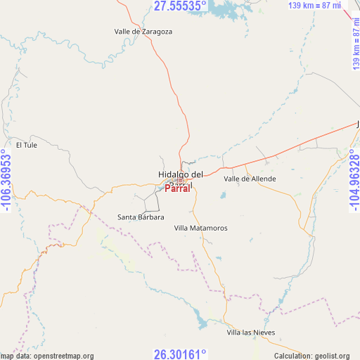
Parral GPS coordinates[2]
26° 55' 48.792" North, 105° 39' 59.04" West
| Map corner | latitude | longitude |
|---|---|---|
| Upper-left | 27.55535°, | -106.36953° |
| Center: | 26.93022°, | -105.6664° |
| Lower-right: | 26.30161°, | -104.96328° |
| Map W x H: | 139.4×139.4 km | = 86.6×86.6mi |
| max Lat: | 32.7° ⇑3.8% North |
| Parral: | 26.93022° |
| min Lat: | ⇓96.2% South 14.53588° |
| min Long | Parral | max Long |
| -117.105° | -105.6664° | -86.73105° |
| W 6.5%⇐ | ⇒93.5% E |
Elevation
Elevation of Parral is 1722 m = 5650 ft, and this is 468.3 m = 1536 ft above average elevation for this country.
| Max E: |
3497 m = 11473 ft | 40.2% |
| Parral | 1722 m 5650 ft | |
| Avg. | 1253.7 m = 4113 ft | |
Min E: |
-1 m = -3 ft | 59.8% |
See also: Parral elevation on elevation.city.
Geographical zone
Parral is located in North temperate zone (between Tropic of Cancer and the Arctic Circle). Distance of this Northern Tropic circle is 388.4 km =241.3 mi to South.| Distance of | km | miles | from Parral |
|---|---|---|---|
| North Pole | 7012.7 | 4357.5 | to North |
| Arctic Circle | 4406.8 | 2738.3 | to North |
| Tropic Cancer | 388.4 | 241.3 | to South |
| Equator | 2994.4 | 1860.6 | to South |


Nearby cities:
15 places around Parral: (largest is in red/bold)
• Coronado
54.7 km =34 mi,  112°
112°
• El Oro
19.5 km =12.1 mi,  247°
247°
• El Tule
60.9 km =37.8 mi,  283°
283°
• Huejotitán
52.6 km =32.7 mi,  285°
285°
• José Esteban Coronado
54.8 km =34.1 mi, 113°
• López
63.1 km =39.2 mi,  82°
82°
• Matamoros
20.4 km =12.7 mi,  156°
156°
• Octaviano López
63.3 km =39.3 mi, 82°
• Pueblito de Allende
34.3 km =21.3 mi, 78°
• Santa Bárbara
20.7 km =12.9 mi,  227°
227°
• Santa María
65.8 km =40.9 mi, 81°
• Talamantes
22.9 km =14.2 mi,  95°
95°
• Valle de Allende
27.1 km =16.8 mi,  88°
88°
• Valle de Zaragoza
59.5 km =37 mi,  346°
346°
• Villa Ocampo
56.7 km =35.2 mi, 163°
Sources, notices
• [Note1] Compared only with cities in Mexico existing in our database
• [Src1] Map data: © OpenStreetMap contributors (CC-BY-SA)
• [Src2] Other city data from geonames.org with taken over terms of usage.
• [Src3] Geographical zone / Annual Mean Temperature by Robert A. Rohde @ Wikipedia
