Revolución geodata
Revolución (Durango) is a populated place; located in Mexico in America/Monterrey (GMT-6) time zone. With population of 931 people, there are 9365 cities with bigger population in this country. Compared to other cities in Mexico, 95.5% of cities are located further ↓South; 92% of cities are located further →East and 66.8% of cities have lower elevation than Revolución. Note1


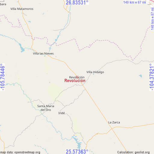
Revolución GPS coordinates[2]
26° 12' 22.248" North, 105° 4' 52.788" West
| Map corner | latitude | longitude |
|---|---|---|
| Upper-left | 26.83531°, | -105.78446° |
| Center: | 26.20618°, | -105.08133° |
| Lower-right: | 25.57363°, | -104.37821° |
| Map W x H: | 140.3×140.3 km | = 87.2×87.2mi |
| max Lat: | 32.7° ⇑4.5% North |
| Revolución: | 26.20618° |
| min Lat: | ⇓95.5% South 14.53588° |
| min Long | Revolución | max Long |
| -117.105° | -105.08133° | -86.73105° |
| W 8%⇐ | ⇒92% E |
Elevation
Elevation of Revolución is 1866 m = 6122 ft, and this is 612.3 m = 2009 ft above average elevation for this country.
| Max E: |
3497 m = 11473 ft | 33.2% |
| Revolución | 1866 m 6122 ft | |
| Avg. | 1253.7 m = 4113 ft | |
Min E: |
-1 m = -3 ft | 66.8% |
See also: Mexico elevation on elevation.city.
Geographical zone
Revolución is located in North temperate zone (between Tropic of Cancer and the Arctic Circle). Distance of this Northern Tropic circle is 307.9 km =191.3 mi to South.| Distance of | km | miles | from Revolución |
|---|---|---|---|
| North Pole | 7093.2 | 4407.5 | to North |
| Arctic Circle | 4487.3 | 2788.3 | to North |
| Tropic Cancer | 307.9 | 191.3 | to South |
| Equator | 2913.9 | 1810.6 | to South |


Nearby cities:
15 places around Revolución: (largest is in red/bold)
• Canutillo
34.9 km =21.7 mi,  303°
303°
• Coronado
59.7 km =37.1 mi,  352°
352°
• General Escobedo
78.6 km =48.8 mi,  191°
191°
• Indé
35.6 km =22.1 mi,  203°
203°
• José Esteban Coronado
59.5 km =37 mi, 352°
• La Zarca
53.4 km =33.2 mi,  140°
140°
• López
88.7 km =55.1 mi,  3°
3°
• Matamoros
79.6 km =49.5 mi,  320°
320°
• San Bernardo
49.8 km =30.9 mi,  242°
242°
• Santa María del Oro
40.2 km =25 mi,  224°
224°
• Talamantes
86.1 km =53.5 mi,  335°
335°
• Torreón de Cañas
26.8 km =16.7 mi,  314°
314°
• Valle de Allende
86.8 km =53.9 mi, 339°
• Villa Hidalgo
17.3 km =10.7 mi,  74°
74°
• Villa Ocampo
49.8 km =30.9 mi, 301°
Sources, notices
• [Note1] Compared only with cities in Mexico existing in our database
• [Src1] Map data: © OpenStreetMap contributors (CC-BY-SA)
• [Src2] Other city data from geonames.org with taken over terms of usage.
• [Src3] Geographical zone / Annual Mean Temperature by Robert A. Rohde @ Wikipedia
