Paracuaro geodata
Paracuaro (Michoacán) is a populated place; located in Mexico in America/Mexico_City (GMT-6) time zone. With population of 3,932 people, there are 2322 cities with bigger population in this country. Compared to other cities in Mexico, 62.2% of cities are located further ↑North; 82.1% of cities are located further →East and 66.5% of cities have higher elevation than Paracuaro. Note1


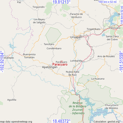
Paracuaro GPS coordinates[2]
19° 8' 57.336" North, 102° 13' 7.356" West
| Map corner | latitude | longitude |
|---|---|---|
| Upper-left | 19.81213°, | -102.92184° |
| Center: | 19.14926°, | -102.21871° |
| Lower-right: | 18.48372°, | -101.51559° |
| Map W x H: | 147.7×147.7 km | = 91.8×91.8mi |
| max Lat: | 32.7° ⇑62.2% North |
| Paracuaro: | 19.14926° |
| min Lat: | ⇓37.8% South 14.53588° |
| min Long | Paracuaro | max Long |
| -117.105° | -102.21871° | -86.73105° |
| W 17.9%⇐ | ⇒82.1% E |
Elevation
Elevation of Paracuaro is 610 m = 2001 ft, and this is 643.7 m = 2112 ft below average elevation for this country.
| Max E: |
3497 m = 11473 ft | 66.5% |
| Avg. | 1253.7 m = 4113 ft | |
| Paracuaro | 610 m = 2001 ft | |
Min E: |
-1 m = -3 ft | 33.5% |
See also: Mexico elevation on elevation.city.
Geographical zone
Paracuaro is located in North Torrid zone (between Equator and Tropic of Cancer). Distance of this Northern Tropic circle is 476.7 km =296.2 mi to North.| Distance of | km | miles | from Paracuaro |
|---|---|---|---|
| North Pole | 7877.9 | 4895.1 | to North |
| Arctic Circle | 5272 | 3275.9 | to North |
| Tropic Cancer | 476.7 | 296.2 | to North |
| Equator | 2129.2 | 1323 | to South |


Nearby cities:
15 places around Paracuaro: (largest is in red/bold)
• Antúnez
15.1 km =9.4 mi,  174°
174°
• Antúnez (Morelos)
15.3 km =9.5 mi, 174°
• Apatzingán
16 km =9.9 mi,  245°
245°
• Buenos Aires
9.2 km =5.7 mi,  153°
153°
• El Caulote
9.5 km =5.9 mi,  106°
106°
• El Ceñidor
16.6 km =10.3 mi, 169°
• Estación Nueva Italia
16.7 km =10.4 mi,  123°
123°
• Fraccionamiento Girasoles
15 km =9.3 mi,  223°
223°
• La Estancia
8 km =5 mi,  31°
31°
• La Huerta
9.1 km =5.7 mi,  232°
232°
• Lombardía
17.6 km =10.9 mi,  86°
86°
• Los Bancos
3.9 km =2.4 mi,  17°
17°
• San Antonio la Labor
15.9 km =9.9 mi,  212°
212°
• Uspero
15.9 km =9.9 mi,  199°
199°
• Veinte de Noviembre
9.4 km =5.8 mi, 199°
Sources, notices
• [Note1] Compared only with cities in Mexico existing in our database
• [Src1] Map data: © OpenStreetMap contributors (CC-BY-SA)
• [Src2] Other city data from geonames.org with taken over terms of usage.
• [Src3] Geographical zone / Annual Mean Temperature by Robert A. Rohde @ Wikipedia
