Mascuala geodata
Mascuala (Jalisco) is a populated place; located in Mexico in America/Mexico_City (GMT-6) time zone. With population of 862 people, there are 10147 cities with bigger population in this country. Compared to other cities in Mexico, 72.8% of cities are located further ↓South; 87% of cities are located further →East and 55.5% of cities have lower elevation than Mascuala. Note1


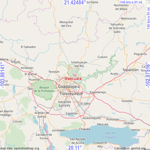
Mascuala GPS coordinates[2]
20° 46' 7.86" North, 103° 16' 41.808" West
| Map corner | latitude | longitude |
|---|---|---|
| Upper-left | 21.42484°, | -103.98141° |
| Center: | 20.76885°, | -103.27828° |
| Lower-right: | 20.11°, | -102.57516° |
| Map W x H: | 146.2×146.2 km | = 90.8×90.8mi |
| max Lat: | 32.7° ⇑27.2% North |
| Mascuala: | 20.76885° |
| min Lat: | ⇓72.8% South 14.53588° |
| min Long | Mascuala | max Long |
| -117.105° | -103.27828° | -86.73105° |
| W 13%⇐ | ⇒87% E |
Elevation
Elevation of Mascuala is 1603 m = 5259 ft, and this is 349.3 m = 1146 ft above average elevation for this country.
| Max E: |
3497 m = 11473 ft | 44.5% |
| Mascuala | 1603 m 5259 ft | |
| Avg. | 1253.7 m = 4113 ft | |
Min E: |
-1 m = -3 ft | 55.5% |
See also: Mexico elevation on elevation.city.
Geographical zone
Mascuala is located in North Torrid zone (between Equator and Tropic of Cancer). Distance of this Northern Tropic circle is 296.6 km =184.3 mi to North.| Distance of | km | miles | from Mascuala |
|---|---|---|---|
| North Pole | 7697.8 | 4783.2 | to North |
| Arctic Circle | 5091.9 | 3164 | to North |
| Tropic Cancer | 296.6 | 184.3 | to North |
| Equator | 2309.3 | 1434.9 | to South |


Nearby cities:
15 places around Mascuala: (largest is in red/bold)
• Coyula
13.4 km =8.3 mi,  156°
156°
• Guadalajara
16.4 km =10.2 mi,  226°
226°
• Ixtlahuacán del Río
11.3 km =7 mi,  20°
20°
• Matatlán
14.9 km =9.3 mi,  116°
116°
• Nuevo Israel
7.9 km =4.9 mi,  171°
171°
• Residencias el Prado (Jardines del Prado)
11.2 km =7 mi,  146°
146°
• San Antonio de los Vázquez
14.8 km =9.2 mi,  68°
68°
• San Esteban (San Miguel Tateposco)
10.5 km =6.5 mi,  288°
288°
• San Isidro
8 km =5 mi, 288°
• Tacotlán
10.8 km =6.7 mi,  59°
59°
• Tlaquepaque
14.3 km =8.9 mi,  186°
186°
• Tonalá
16.7 km =10.4 mi, 164°
• Trejos
8.9 km =5.5 mi, 71°
• Zapopan
12.2 km =7.6 mi,  245°
245°
• Zapopan2
13.9 km =8.6 mi, 245°
Sources, notices
• [Note1] Compared only with cities in Mexico existing in our database
• [Src1] Map data: © OpenStreetMap contributors (CC-BY-SA)
• [Src2] Other city data from geonames.org with taken over terms of usage.
• [Src3] Geographical zone / Annual Mean Temperature by Robert A. Rohde @ Wikipedia
