San Luis Soyatlán geodata
San Luis Soyatlán (Jalisco) is a populated place; located in Mexico in America/Mexico_City (GMT-6) time zone. With population of 3,512 people, there are 2601 cities with bigger population in this country. Compared to other cities in Mexico, 61.3% of cities are located further ↓South; 87.2% of cities are located further →East and 52.9% of cities have lower elevation than San Luis Soyatlán. Note1


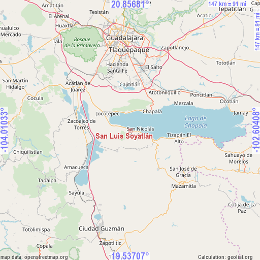
San Luis Soyatlán GPS coordinates[2]
20° 11' 54.024" North, 103° 18' 25.92" West
| Map corner | latitude | longitude |
|---|---|---|
| Upper-left | 20.85681°, | -104.01033° |
| Center: | 20.19834°, | -103.3072° |
| Lower-right: | 19.53707°, | -102.60408° |
| Map W x H: | 146.7×146.7 km | = 91.2×91.2mi |
| max Lat: | 32.7° ⇑38.7% North |
| San Luis Soyatlán: | 20.19834° |
| min Lat: | ⇓61.3% South 14.53588° |
| min Long | San Luis Soyatl | max Long |
| -117.105° | -103.3072° | -86.73105° |
| W 12.8%⇐ | ⇒87.2% E |
Elevation
Elevation of San Luis Soyatlán is 1540 m = 5052 ft, and this is 286.3 m = 939 ft above average elevation for this country.
| Max E: |
3497 m = 11473 ft | 47.1% |
| San Luis Soyatlán | 1540 m 5052 ft | |
| Avg. | 1253.7 m = 4113 ft | |
Min E: |
-1 m = -3 ft | 52.9% |
See also: Mexico elevation on elevation.city.
Geographical zone
San Luis Soyatlán is located in North Torrid zone (between Equator and Tropic of Cancer). Distance of this Northern Tropic circle is 360.1 km =223.8 mi to North.| Distance of | km | miles | from San Luis Soyatlán |
|---|---|---|---|
| North Pole | 7761.2 | 4822.6 | to North |
| Arctic Circle | 5155.3 | 3203.4 | to North |
| Tropic Cancer | 360.1 | 223.8 | to North |
| Equator | 2245.8 | 1395.5 | to South |


Nearby cities:
15 places around San Luis Soyatlán: (largest is in red/bold)
• Ajijic
12.9 km =8 mi,  25°
25°
• Cacaluta
18.7 km =11.6 mi,  259°
259°
• Chapala
16.3 km =10.1 mi,  48°
48°
• Citala
11.4 km =7.1 mi,  155°
155°
• Jocotepec
16 km =9.9 mi,  307°
307°
• Las Trojes
15.3 km =9.5 mi,  351°
351°
• Milpilla
11.9 km =7.4 mi,  236°
236°
• Potrerillos
17.2 km =10.7 mi,  334°
334°
• San Cristóbal Zapotitlán
7.1 km =4.4 mi,  294°
294°
• San José de Gracia
17.9 km =11.1 mi,  231°
231°
• San Juan Cosalá
10.5 km =6.5 mi,  340°
340°
• San Pedro Tesistán
11.7 km =7.3 mi, 285°
• Teocuitatlán de Corona
13.9 km =8.6 mi,  212°
212°
• Tepeguaje
10.2 km =6.3 mi,  107°
107°
• Tuxcueca
13.7 km =8.5 mi, 111°
Sources, notices
• [Note1] Compared only with cities in Mexico existing in our database
• [Src1] Map data: © OpenStreetMap contributors (CC-BY-SA)
• [Src2] Other city data from geonames.org with taken over terms of usage.
• [Src3] Geographical zone / Annual Mean Temperature by Robert A. Rohde @ Wikipedia
