López geodata
López (Chihuahua) is a seat of a second-order administrative division; located in Mexico in America/Chihuahua (GMT-6) time zone. In our database, there are 16903 cities with bigger population. Compared to other cities in Mexico, 96.3% of cities are located further ↓South; 91.9% of cities are located further →East and 50.1% of cities have higher elevation than López. Note1


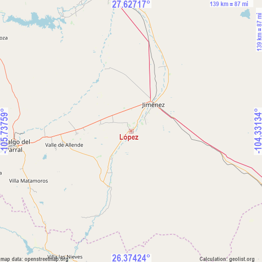
López GPS coordinates[2]
27° 0' 8.82" North, 105° 2' 4.056" West
| Map corner | latitude | longitude |
|---|---|---|
| Upper-left | 27.62717°, | -105.73759° |
| Center: | 27.00245°, | -105.03446° |
| Lower-right: | 26.37424°, | -104.33134° |
| Map W x H: | 139.3×139.3 km | = 86.6×86.6mi |
| max Lat: | 32.7° ⇑3.7% North |
| López: | 27.00245° |
| min Lat: | ⇓96.3% South 14.53588° |
| min Long | López | max Long |
| -117.105° | -105.03446° | -86.73105° |
| W 8.1%⇐ | ⇒91.9% E |
Elevation
Elevation of López is 1425 m = 4675 ft, and this is 171.3 m = 562 ft above average elevation for this country.
| Max E: |
3497 m = 11473 ft | 50.1% |
| López | 1425 m 4675 ft | |
| Avg. | 1253.7 m = 4113 ft | |
Min E: |
-1 m = -3 ft | 49.9% |
See also: Mexico elevation on elevation.city.
Geographical zone
López is located in North temperate zone (between Tropic of Cancer and the Arctic Circle). Distance of this Northern Tropic circle is 396.5 km =246.4 mi to South.| Distance of | km | miles | from López |
|---|---|---|---|
| North Pole | 7004.7 | 4352.5 | to North |
| Arctic Circle | 4398.8 | 2733.3 | to North |
| Tropic Cancer | 396.5 | 246.4 | to South |
| Equator | 3002.4 | 1865.6 | to South |


Nearby cities:
15 places around López: (largest is in red/bold)
• Boquilla de Babisas (La Boquilla de Conchos)
70.8 km =44 mi,  329°
329°
• Camargo
76.4 km =47.5 mi,  349°
349°
• Conchos
71.4 km =44.4 mi,  335°
335°
• Coronado
31.9 km =19.8 mi,  202°
202°
• Escalón
74.1 km =46 mi,  112°
112°
• José Esteban Coronado
31.9 km =19.8 mi, 202°
• José Mariano Jiménez
18 km =11.2 mi,  37°
37°
• Matamoros
60.8 km =37.8 mi,  243°
243°
• Octaviano López
0.1 km =0.1 mi,  87°
87°
• Parral
63.1 km =39.2 mi,  262°
262°
• Pueblito de Allende
29 km =18 mi,  267°
267°
• Santa María
3.3 km =2.1 mi,  48°
48°
• Talamantes
41.1 km =25.5 mi, 255°
• Torreón de Cañas
73.8 km =45.9 mi, 198°
• Valle de Allende
36.3 km =22.6 mi, 258°
Sources, notices
• [Note1] Compared only with cities in Mexico existing in our database
• [Src1] Map data: © OpenStreetMap contributors (CC-BY-SA)
• [Src2] Other city data from geonames.org with taken over terms of usage.
• [Src3] Geographical zone / Annual Mean Temperature by Robert A. Rohde @ Wikipedia
