Santa María geodata
Santa María (Chihuahua) is a populated place; located in Mexico in America/Chihuahua (GMT-6) time zone. With population of 602 people, there are 14290 cities with bigger population in this country. Compared to other cities in Mexico, 96.3% of cities are located further ↓South; 91.9% of cities are located further →East and 50.3% of cities have higher elevation than Santa María. Note1


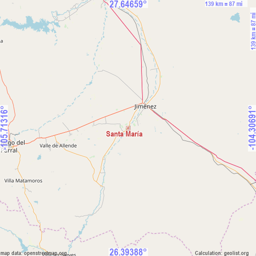
Santa María GPS coordinates[2]
27° 1' 19.128" North, 105° 0' 36.108" West
| Map corner | latitude | longitude |
|---|---|---|
| Upper-left | 27.64659°, | -105.71316° |
| Center: | 27.02198°, | -105.01003° |
| Lower-right: | 26.39388°, | -104.30691° |
| Map W x H: | 139.3×139.3 km | = 86.6×86.6mi |
| max Lat: | 32.7° ⇑3.7% North |
| Santa María: | 27.02198° |
| min Lat: | ⇓96.3% South 14.53588° |
| min Long | Santa María | max Long |
| -117.105° | -105.01003° | -86.73105° |
| W 8.1%⇐ | ⇒91.9% E |
Elevation
Elevation of Santa María is 1419 m = 4656 ft, and this is 165.3 m = 542 ft above average elevation for this country.
| Max E: |
3497 m = 11473 ft | 50.3% |
| Santa María | 1419 m 4656 ft | |
| Avg. | 1253.7 m = 4113 ft | |
Min E: |
-1 m = -3 ft | 49.7% |
See also: Mexico elevation on elevation.city.
Geographical zone
Santa María is located in North temperate zone (between Tropic of Cancer and the Arctic Circle). Distance of this Northern Tropic circle is 398.6 km =247.7 mi to South.| Distance of | km | miles | from Santa María |
|---|---|---|---|
| North Pole | 7002.5 | 4351.2 | to North |
| Arctic Circle | 4396.6 | 2731.9 | to North |
| Tropic Cancer | 398.6 | 247.7 | to South |
| Equator | 3004.6 | 1867 | to South |


Nearby cities:
15 places around Santa María: (largest is in red/bold)
• Boquilla de Babisas (La Boquilla de Conchos)
70.3 km =43.7 mi,  326°
326°
• Camargo
74.7 km =46.4 mi,  347°
347°
• Conchos
70.5 km =43.8 mi, 333°
• Coronado
34.8 km =21.6 mi,  205°
205°
• Escalón
72.7 km =45.2 mi,  114°
114°
• José Esteban Coronado
34.9 km =21.7 mi,  204°
204°
• José Mariano Jiménez
14.8 km =9.2 mi,  35°
35°
• López
3.3 km =2.1 mi,  228°
228°
• Matamoros
63.9 km =39.7 mi,  243°
243°
• Octaviano López
3.1 km =1.9 mi, 226°
• Parral
65.8 km =40.9 mi,  261°
261°
• Pueblito de Allende
31.6 km =19.6 mi, 263°
• Talamantes
44 km =27.3 mi,  253°
253°
• Torreón de Cañas
76.6 km =47.6 mi, 199°
• Valle de Allende
39.1 km =24.3 mi, 255°
Sources, notices
• [Note1] Compared only with cities in Mexico existing in our database
• [Src1] Map data: © OpenStreetMap contributors (CC-BY-SA)
• [Src2] Other city data from geonames.org with taken over terms of usage.
• [Src3] Geographical zone / Annual Mean Temperature by Robert A. Rohde @ Wikipedia
