Villa de Cos geodata
Villa de Cos (Zacatecas) is a seat of a second-order administrative division; located in Mexico in America/Mexico_City (GMT-6) time zone. With population of 5,759 people, there are 1617 cities with bigger population in this country. Compared to other cities in Mexico, 88.6% of cities are located further ↓South; 83.3% of cities are located further →East and 72.7% of cities have lower elevation than Villa de Cos. Note1


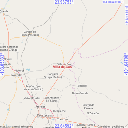
Villa de Cos GPS coordinates[2]
23° 17' 35.844" North, 102° 21' 0.72" West
| Map corner | latitude | longitude |
|---|---|---|
| Upper-left | 23.93753°, | -103.05333° |
| Center: | 23.29329°, | -102.3502° |
| Lower-right: | 22.64592°, | -101.64708° |
| Map W x H: | 143.6×143.6 km | = 89.2×89.2mi |
| max Lat: | 32.7° ⇑11.4% North |
| Villa de Cos: | 23.29329° |
| min Lat: | ⇓88.6% South 14.53588° |
| min Long | Villa de Cos | max Long |
| -117.105° | -102.3502° | -86.73105° |
| W 16.7%⇐ | ⇒83.3% E |
Elevation
Elevation of Villa de Cos is 1982 m = 6503 ft, and this is 728.3 m = 2389 ft above average elevation for this country.
| Max E: |
3497 m = 11473 ft | 27.3% |
| Villa de Cos | 1982 m 6503 ft | |
| Avg. | 1253.7 m = 4113 ft | |
Min E: |
-1 m = -3 ft | 72.7% |
See also: Mexico elevation on elevation.city.
Geographical zone
Villa de Cos is located in North Torrid zone (between Equator and Tropic of Cancer). Distance of this Northern Tropic circle is 15.9 km =9.9 mi to North.| Distance of | km | miles | from Villa de Cos |
|---|---|---|---|
| North Pole | 7417.1 | 4608.8 | to North |
| Arctic Circle | 4811.2 | 2989.5 | to North |
| Tropic Cancer | 15.9 | 9.9 | to North |
| Equator | 2590 | 1609.4 | to South |


Nearby cities:
15 places around Villa de Cos: (largest is in red/bold)
• Cañas
18 km =11.2 mi,  28°
28°
• Chaparrosa
24.5 km =15.2 mi,  162°
162°
• Chichimequillas
24.1 km =15 mi,  255°
255°
• Chupaderos
15.2 km =9.4 mi,  170°
170°
• El Rucio
30.2 km =18.8 mi,  65°
65°
• Gonzales Ortega
17.9 km =11.1 mi,  225°
225°
• Illescas
21.8 km =13.5 mi,  105°
105°
• Jesús María
22.3 km =13.9 mi,  133°
133°
• La Prieta
23 km =14.3 mi, 68°
• Laguna Seca
29.7 km =18.5 mi,  209°
209°
• Rafael Yáñez Sosa (El Mezquite)
26.8 km =16.7 mi,  278°
278°
• San Juan
31.3 km =19.4 mi,  186°
186°
• San Ramón
17.7 km =11 mi, 206°
• Tierra y Libertad (San Blas)
18.3 km =11.4 mi,  347°
347°
• Zancarron
16 km =9.9 mi,  56°
56°
Sources, notices
• [Note1] Compared only with cities in Mexico existing in our database
• [Src1] Map data: © OpenStreetMap contributors (CC-BY-SA)
• [Src2] Other city data from geonames.org with taken over terms of usage.
• [Src3] Geographical zone / Annual Mean Temperature by Robert A. Rohde @ Wikipedia
