Cañas geodata
Cañas (Zacatecas) is a populated place; located in Mexico in America/Mexico_City (GMT-6) time zone. With population of 598 people, there are 14373 cities with bigger population in this country. Compared to other cities in Mexico, 88.9% of cities are located further ↓South; 82.5% of cities are located further →East and 73.9% of cities have lower elevation than Cañas. Note1


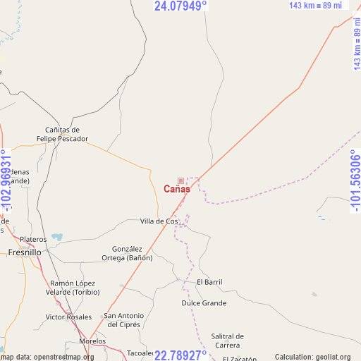
Cañas GPS coordinates[2]
23° 26' 9.42" North, 102° 15' 58.248" West
| Map corner | latitude | longitude |
|---|---|---|
| Upper-left | 24.07949°, | -102.96931° |
| Center: | 23.43595°, | -102.26618° |
| Lower-right: | 22.78927°, | -101.56306° |
| Map W x H: | 143.5×143.5 km | = 89.2×89.2mi |
| max Lat: | 32.7° ⇑11.1% North |
| Cañas: | 23.43595° |
| min Lat: | ⇓88.9% South 14.53588° |
| min Long | Cañas | max Long |
| -117.105° | -102.26618° | -86.73105° |
| W 17.5%⇐ | ⇒82.5% E |
Elevation
Elevation of Cañas is 2009 m = 6591 ft, and this is 755.3 m = 2478 ft above average elevation for this country.
| Max E: |
3497 m = 11473 ft | 26.1% |
| Cañas | 2009 m 6591 ft | |
| Avg. | 1253.7 m = 4113 ft | |
Min E: |
-1 m = -3 ft | 73.9% |
See also: Mexico elevation on elevation.city.
Geographical zone
Cañas is located in North Torrid zone (between Equator and Tropic of Cancer). Distance of this Northern Tropic circle is 0.1 km =0.1 mi to North.| Distance of | km | miles | from Cañas |
|---|---|---|---|
| North Pole | 7401.2 | 4598.9 | to North |
| Arctic Circle | 4795.3 | 2979.7 | to North |
| Tropic Cancer | 0.1 | 0.1 | to North |
| Equator | 2605.8 | 1619.2 | to South |


Nearby cities:
15 places around Cañas: (largest is in red/bold)
• Cervantes
26.3 km =16.3 mi,  100°
100°
• Chupaderos
31.4 km =19.5 mi,  191°
191°
• El Rucio
19.1 km =11.9 mi, 99°
• Emiliano Zapata (San Antonio del Burro)
19.2 km =11.9 mi,  33°
33°
• Gonzales Ortega
35.6 km =22.1 mi,  217°
217°
• Guadalupe de las Corrientes
37.9 km =23.5 mi,  320°
320°
• Illescas
25 km =15.5 mi,  150°
150°
• Jesús María
32.1 km =19.9 mi,  166°
166°
• La Prieta
14.9 km =9.3 mi,  120°
120°
• Mezquitillo
30.5 km =19 mi,  307°
307°
• Rafael Yáñez Sosa (El Mezquite)
37.1 km =23.1 mi,  251°
251°
• San Ramón
35.8 km =22.2 mi,  207°
207°
• Tierra y Libertad (San Blas)
12.7 km =7.9 mi,  278°
278°
• Villa de Cos
18 km =11.2 mi, 208°
• Zancarron
8.5 km =5.3 mi, 145°
Sources, notices
• [Note1] Compared only with cities in Mexico existing in our database
• [Src1] Map data: © OpenStreetMap contributors (CC-BY-SA)
• [Src2] Other city data from geonames.org with taken over terms of usage.
• [Src3] Geographical zone / Annual Mean Temperature by Robert A. Rohde @ Wikipedia
