San Juan geodata
San Juan (Zacatecas) is a populated place; located in Mexico in America/Mexico_City (GMT-6) time zone. With population of 808 people, there are 10815 cities with bigger population in this country. Compared to other cities in Mexico, 88% of cities are located further ↓South; 83.4% of cities are located further →East and 75% of cities have lower elevation than San Juan. Note1


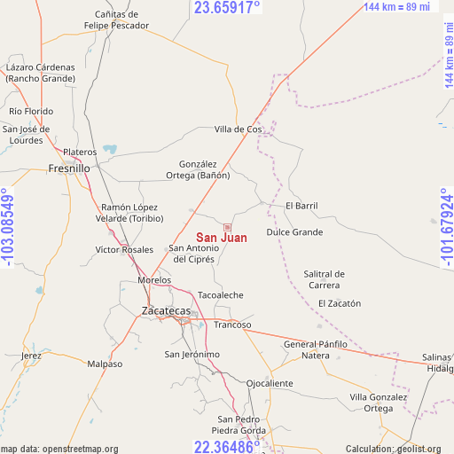
San Juan GPS coordinates[2]
23° 0' 48.852" North, 102° 22' 56.496" West
| Map corner | latitude | longitude |
|---|---|---|
| Upper-left | 23.65917°, | -103.08549° |
| Center: | 23.01357°, | -102.38236° |
| Lower-right: | 22.36486°, | -101.67924° |
| Map W x H: | 143.9×143.9 km | = 89.4×89.4mi |
| max Lat: | 32.7° ⇑12% North |
| San Juan: | 23.01357° |
| min Lat: | ⇓88% South 14.53588° |
| min Long | San Juan | max Long |
| -117.105° | -102.38236° | -86.73105° |
| W 16.6%⇐ | ⇒83.4% E |
Elevation
Elevation of San Juan is 2030 m = 6660 ft, and this is 776.3 m = 2547 ft above average elevation for this country.
| Max E: |
3497 m = 11473 ft | 25% |
| San Juan | 2030 m 6660 ft | |
| Avg. | 1253.7 m = 4113 ft | |
Min E: |
-1 m = -3 ft | 75% |
See also: Mexico elevation on elevation.city.
Geographical zone
San Juan is located in North Torrid zone (between Equator and Tropic of Cancer). Distance of this Northern Tropic circle is 47 km =29.2 mi to North.| Distance of | km | miles | from San Juan |
|---|---|---|---|
| North Pole | 7448.2 | 4628.1 | to North |
| Arctic Circle | 4842.3 | 3008.9 | to North |
| Tropic Cancer | 47 | 29.2 | to North |
| Equator | 2558.9 | 1590 | to South |


Nearby cities:
15 places around San Juan: (largest is in red/bold)
• Casa Blanca
16.2 km =10.1 mi,  151°
151°
• Casa de Cerros
20.2 km =12.6 mi,  224°
224°
• Chaparrosa
13.3 km =8.3 mi,  54°
54°
• Chupaderos
17.2 km =10.7 mi,  19°
19°
• Dulce Grande
21.4 km =13.3 mi,  93°
93°
• El Lampotal
13.6 km =8.5 mi,  196°
196°
• Gonzales Ortega
20.9 km =13 mi,  332°
332°
• La Luz
16.6 km =10.3 mi, 153°
• Laguna Seca
12.8 km =8 mi,  294°
294°
• Los Pozos
11.2 km =7 mi,  260°
260°
• Pozos de Gamboa
20.5 km =12.7 mi,  249°
249°
• San Antonio del Cipres
13.6 km =8.5 mi,  232°
232°
• San José de la Era
18.6 km =11.6 mi,  192°
192°
• San Ramón
16 km =9.9 mi,  342°
342°
• Santa Rita
11.9 km =7.4 mi, 198°
Sources, notices
• [Note1] Compared only with cities in Mexico existing in our database
• [Src1] Map data: © OpenStreetMap contributors (CC-BY-SA)
• [Src2] Other city data from geonames.org with taken over terms of usage.
• [Src3] Geographical zone / Annual Mean Temperature by Robert A. Rohde @ Wikipedia
